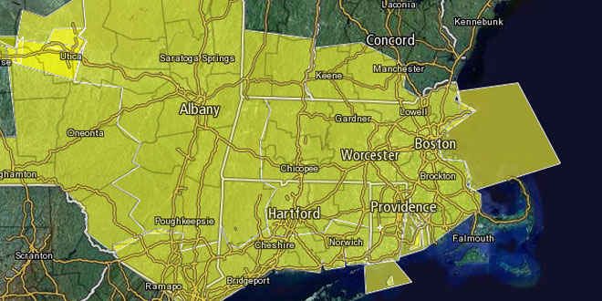
The National Weather Service has issued a Severe Thunderstorm Watch for most of Southern New England until 9 pm Monday. All of Southern New England except for Cape Cod, Martha’s Vineyard and Nantucket is included in the watch area. Conditions are favorable for strong to severe thunderstorms to develop in advance of a cold front from late in the afternoon through the mid-evening hours. The primary severe weather threats are strong, damaging straight-line winds and the potential for large hail. Be prepared to take cover if these severe storms develop.
A Severe Thunderstorm Watch does not mean that a severe thunderstorm is imminent, but, rather, that conditions are favorable for storms to develop and some may become severe. See additional information below from the National Weather Service Storm Prediction Center.

 URGENT - IMMEDIATE BROADCAST REQUESTED
   SEVERE THUNDERSTORM WATCH NUMBER 321
   NWS STORM PREDICTION CENTER NORMAN OK
   115 PM EDT MON JUN 17 2013

   THE NWS STORM PREDICTION CENTER HAS ISSUED A

   * SEVERE THUNDERSTORM WATCH FOR PORTIONS OF
     CONNECTICUT
     MASSACHUSETTS
     SOUTHERN NEW HAMPSHIRE
     EASTERN NEW YORK
     RHODE ISLAND
     SOUTHERN VERMONT
     COASTAL WATERS

   * EFFECTIVE THIS MONDAY AFTERNOON AND EVENING FROM 115 PM UNTIL
     900 PM EDT.

   * PRIMARY THREATS INCLUDE...
     SEVERAL DAMAGING WIND GUSTS TO 70 MPH POSSIBLE
     SEVERAL LARGE HAIL EVENTS TO 1.5 INCHES IN DIAMETER POSSIBLE

   THE SEVERE THUNDERSTORM WATCH AREA IS APPROXIMATELY ALONG AND 70
   STATUTE MILES NORTH AND SOUTH OF A LINE FROM 60 MILES NORTH
   NORTHWEST OF MONTICELLO NEW YORK TO 15 MILES EAST OF BOSTON
   MASSACHUSETTS.  FOR A COMPLETE DEPICTION OF THE WATCH SEE THE
   ASSOCIATED WATCH OUTLINE UPDATE (WOUS64 KWNS WOU1).

   PRECAUTIONARY/PREPAREDNESS ACTIONS...

   REMEMBER...A SEVERE THUNDERSTORM WATCH MEANS CONDITIONS ARE
   FAVORABLE FOR SEVERE THUNDERSTORMS IN AND CLOSE TO THE WATCH
   AREA. PERSONS IN THESE AREAS SHOULD BE ON THE LOOKOUT FOR
   THREATENING WEATHER CONDITIONS AND LISTEN FOR LATER STATEMENTS
   AND POSSIBLE WARNINGS. SEVERE THUNDERSTORMS CAN AND OCCASIONALLY
   DO PRODUCE TORNADOES.

   &&

   DISCUSSION...THUNDERSTORMS WILL CONTINUE TO INCREASE AND INTENSIFY
   THIS AFTERNOON AHEAD OF A COLD FRONT. WHILE MOISTURE/INSTABILITY IS
   RELATIVELY MODEST...STRONG LOW TO MID-LEVEL WESTERLY WINDS WILL
   ALLOW FOR THE MATURATION OF EAST-SOUTHEASTWARD MOVING MULTICELLULAR
   LINE SEGMENTS/SMALL BOWS CAPABLE OF WIND DAMAGE ASIDE FROM SEVERE
   HAIL.

   AVIATION...A FEW SEVERE THUNDERSTORMS WITH HAIL SURFACE AND ALOFT
   TO 1.5 INCHES. EXTREME TURBULENCE AND SURFACE WIND GUSTS TO 60
   KNOTS. A FEW CUMULONIMBI WITH MAXIMUM TOPS TO 450. MEAN STORM
   MOTION VECTOR 28030.

   ...GUYER


