Mid-summer heat and humidity returned to Southern New England in a big way on Wednesday. Highs in the 90s inland combined with stifling humidity to make it feel like the low 100s in the afternoon. The temperature spiked to 97° in Boston – the second hottest day of summer. It hit the low 90s at TF Green Airport before a southerly breeze kicked in. Hartford and Worcester both reached 90°. As expected, the high temperatures came up short of the records for the date. Near the coast the temperature fell back into the 70s by late in the day after reaching the mid 80s around midday. Dew points were very uncomfortable, with most spots in the low to mid 70s.
There is the chance of a passing shower or thunderstorm west of the I-95 corridor Wednesday night. Storms in W MA and W CT could be strong to severe through late in the evening. Patchy fog is possible near the coast. It will stay awfully humid, with lows in the upper 60s to low 70s – about 15 degrees warmer than normal for mid-September!

Thursday will be equally humid, but not as warm. Highs may flirt with 90° in a northeast MA, but most of the Southern New England will be in the upper 70s to mid 80s. The sky will be hazy again, with very high humidity. There is a better chance of showers and thunderstorms on Thursday – especially from the evening into Friday morning.
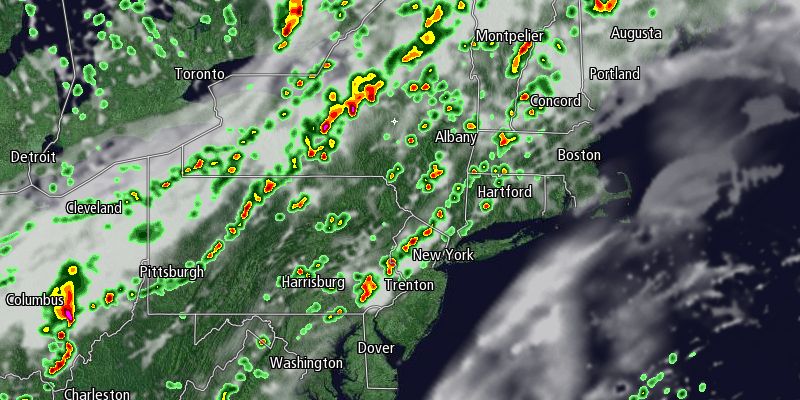
Storms should fire in Upstate NY, Northern New England, and W CT and W MA during the afternoon. The line of storms will move east, and probably weaken some as it nears the coast. There is the potential for strong winds and hail in the storms – especially over the interior Northeast. The best chance of rain from the I-95 corridor to the coast is not until after midnight.
The cold front triggering the thunderstorms will absorb what is left of Gabrielle as that system heads north in the Atlantic Ocean. Showers will linger into Friday morning, with the best chance of rain after mid-morning in Eastern Massachusetts. Skies will clear from west to east Friday afternoon as system moves farther offshore. It will turn noticeably less humid on Friday, and highs will be in the low to mid 70s.
The weekend still looks dry and seasonably cool. Saturday will be partly sunny with highs in the mid to upper 60s. The temperature will drop into the 40s to low 50s under clear skies Saturday night. Sunday looks delightful, with plenty of sunshine and highs in the upper 60s to low 70s. Another cold front will move through the Northeast early next week opening the doors to even cooler weather by midweek.


