Seasonal forecasting is a tough business. Just look at the Atlantic hurricane season. It was predicted to be very active, and turned out to be a huge dud with no major hurricanes forming. Maybe that blown forecast has everyone a little gun-shy about going to extremes with this winter forecast. Most of the outlooks that I have seen have included a lot of talk about no major weather pattern drivers (El Niño /La Niña) in place to give forecasters a good read on the season. While that is true, I think it is possible to have an idea about what this winter will be like based on all the evidence I’ve seen from different long-range computer models.
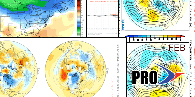
This much is nearly certain, the first two weeks of December will feature a huge cold shot for the Western United States. In the east, the temperature will bounce around, and the storm track should become more active compared to most of the fall. As you’ll see in the video, some computer models (not necessarily the U.S. ones) show a 500 mb pattern that takes the big Western US trough and propagates it east over the course of the winter. If that occurs, then most of the country should end up with some semblance of a winter. It will be early in the west and middle to late in the east.
We foresee a lot of battleground storms, especially early in the winter, as the cold air tries to come east. Mixed precipitation in Southern New England could be a theme for most of December, and possibly beyond. Last winter you may remember a lot of talk about the Siberian Snow Advance Index and its impact on the winter in the Eastern US. This year, the SAI was low, and that usually correlates to a positive Arctic Oscillation, which in turn leads to a relatively mild winter. But there’s more to the story. While the SAI was low, the SCE (Snow Cover Extent) was high, and that correlates favorably with a big Mid-Atlantic or Northeast storm at some point in the winter. Judah Cohen, from Atmospheric and Environmental Research in Massachusetts, who has studied Siberian snow cover and the ensuing East Coast winters for many years says there has never been a case like this in the past 40 years, so there is sure to be something learned.
If you watch the video, you’ll get a lot of model talk and it ultimately boils down to the headlines you see below. We expect there to be a winter in Southern New England. Temperatures near normal are nothing to get excited about if you have a disdain for chilly weather. Southern New England winters are normally cold. As for the snowfall, we think it will be near to slightly above normal in Providence, but could be farther above normal in the interior Northeast. Some of the battleground storms may be mainly snow from Worcester north, but more rain and mixed precipitation in Providence and near the coast. We’ll throw our hat in the ring with the correlation between the high SCE and the big Northeast snowstorm, but it’s not without a lot of trepidation. Typically, Providence sees a 12″ storm once every five years. Last year featured the big blizzard in early February. It’s possible the big event could be an 8″ storm in Providence with some mixed precip., and a 16″ all-snow storm up the road in Worcester.
Our one true coin flip prediction is whether there will be a white Christmas. My 6-year-old daughter is already asking about it, and this year I just can’t say no, so, hopefully I’m right in predicting a white Christmas in 2013.
For all the scorekeepers…last year our forecast worked out pretty well.
Temperature
Predicted – near to below normal (much colder than last year)
Actual – it was warmer than normal, but colder than the previous year
Snowfall
Predicted – 35-55″ in Providence, more than twice the winter before
Actual – 46.3″ in Providence. It’s kind of hard to do better than that!
12″ Storm
Predicted – Yes
Actual – 18″ storm on February 8-9, 2013
White Christmas
Predicted – No
Actual – No, but barely. There was snow on Christmas, but not enough to constitute a White Christmas in the record books. You need 1″, there was only 0.3″.


