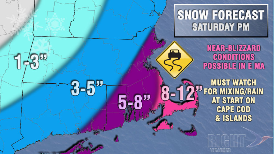
The active winter of 2013-2014 continues with yet another moderate to heavy Southern New England snowstorm on Saturday. The day will become mostly cloudy with snow developing during the mid-afternoon and getting steady by late in the day. Precipitation should arrive between 2-4 pm. It may be a rain/snow mix initially, but it should quickly change to snow for all except Cape Cod where the mix pay persist for a few hours. Highs will be in the mid to upper 30s on Saturday.
The precipitation will get steadier by sunset, and snow may be heavy at times during the evening. It is a close call between rain and snow on Cape Cod and the islands, and we are favoring wet, heavy snow. The wind will increase to 15-35 mph inland during the evening. Winds will be strongest near the coast, with 20-35 mph sustained winds, and 40-45 mph gusts at the RI coast. Near Buzzards Bay the wind may gust to 50 mph if the storm tracks close to Nantucket. 60 mph gusts are possible on Cape Cod and the islands. Blizzard conditions are possible in Eastern MA and the National Weather Service has issued a Blizzard Watch as well as a Winter Storm Warning for RI and SE MA.
The storm will not be long-lived, and the snow will quickly end from west to east after midnight. Skies will partly clear by dawn, and it will stay windy with 30-50 mph gusts likely through dawn. The temperature will fall into the teens to low 20s late Saturday night.

Our snow accumulation forecast is based on the storm tracking close enough to Nantucket to bring heavy snow to Southeastern Massachusetts, and moderate to briefly heavy snow to RI and interior SE MA. If the storm tracks farther east, then the heavier snow will be pushed east and out of RI and interior SE MA. Check with rightweather.com on Saturday morning if you have plans for Saturday evening. It is possible the storm will take a track farther east, and we do not recommend canceling plans before Saturday morning, unless you must.
Sunday and Monday will be quiet and cold. It will be blustery with a high near 30 on Sunday under partly sunny skies. Monday will be very cold in the morning, with lows in the single digits to low teens. Look for afternoon sunshine and highs in the low 30s.
Another system arrives on Tuesday. It will not take a track that is favorable for heavy accumulating snow. Right now, it looks like a rain/snow mix with minor accumulations inland during the day on Tuesday. The temperature may reach the 40s later in the week.


