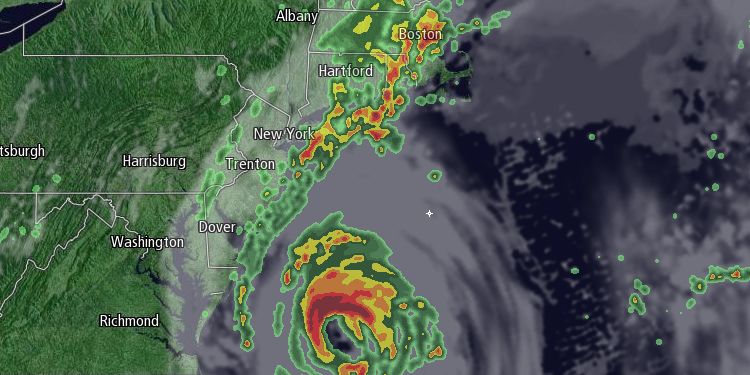
Hurricane Arthur will combine with a stalled cold front to bring drenching downpours to Southeastern Massachusetts on the 4th of July. Of course, there is a lot going on around the holiday, including scheduled fireworks displays on Thursday and Friday, plus the parades and cookouts. Here is a detailed forecast for Southeastern Massachusetts during the Independence Day holiday.
If you will be spending the day in Rhode Island, that forecast is here: http://goo.gl/1txSpU

Thursday Night – Mostly cloudy, patchy fog, slight chance of showers and thunderstorms. Even without showers, low clouds and fog may impact fireworks displays, especially near the coast. Very mild and muggy.
Lows: 68-74
Wind: SW 5-15 mph
Friday Morning – Mostly cloudy, patchy fog early. Stray showers are possible, but, right now, it looks like steady rain will hold off until the afternoon. Very humid. Breezy near the coast.
Temperature: 75-80
Wind: SSW 5-15 mph
Friday Afternoon – Rain develops from west to east, chance of thunderstorms. Torrential downpours likely by mid-afternoon west of New Bedford. Rain may hold off on Cape Cod and islands until after 2 pm. Periods of heavy rain likely everywhere late in the afternoon. Flash flooding possible.
Temperature: 75-80, falling to 65-70
Wind: Becoming N 10-25 mph
Friday Night – Rain likely, heavy at times, ending after midnight. Flood threat continues through the evening. Becoming breezy inland, windy near Buzzards Bay. Wind may gust to tropical storm force on Cape Cod and islands.
Temperature: 60-65
Wind: N 15-25 mph inland, 20-40 mph near Buzzards Bay, 45-60 mph gusts possible on Cape Cod and islands
Saturday – Early clouds, then mostly sunny, breezy, and dry.
Highs: 76-82
Wind: W 15-30 mph early, then 10-20 mph
Rain/Flooding Potential
1.5-3″ of rain is likely in SE MA, with the potential for some areas to see 4-6″, which would easily be enough to cause widespread street and stream flooding. Heaviest rain likely in the late-afternoon and evening.
Marine Impact
Rough seas and high surf are likely through Saturday. 4-6 ft. waves at the entrance to the bay. 6-12 ft. seas offshore. 2-5 ft. surf likely at area beaches Saturday. High rip current risk possible.
Wind Damage Potential
We are closely watching a trend that has the storm coming a bit closer to Nantucket as it moves by Friday night. If that happens, then a period of potentially damaging 50-60 mph wind is possible on Nantucket. A closer track could also bring 40-50 mph wind to Cape Cod.


