Hurricane Arthur was battering the North Carolina coast Thursday evening, and the storm is expected to move through the Outer Banks, then race to the northeast passing east of Nantucket Friday night. The storm may come a bit closer to Southern New England than recently projected, and that could mean a bigger wind impact on Cape Cod and the islands.
Track Hurricane Arthur: http://bit.ly/hurricane-track

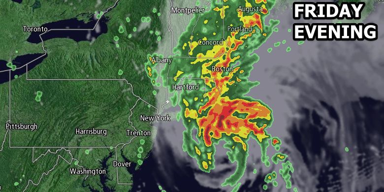
Before any rain from Arthur arrives, a cold front will serve as a focal point for showers and thunderstorms to develop from west to east through Southern New England during the day on Friday. Rain may hold off for part of the Bristol 4th of July parade, but showers and thunderstorms will likely develop by midday, and heavy rain is likely in the afternoon in RI and SE MA. For a Rhode Island specific forecast click here. For a Southeastern Massachusetts specific forecast click here.
Rain will be heavy at times late Friday afternoon through Friday evening. The heaviest rain may be in SE RI and interior SE MA, where more than 3″ of rain is possible. Most of Southeastern New England will see at least an inch of rain. The hardest hit areas could get 5″ if showers develop before the rain from Arthur arrives. Flash flooding is possible in RI and SE MA. The temperature will fall from the upper 70s to low 80s by late in the morning, to the low to mid 60s by early in the evening as the wind swings around to the east and then north.
A track nearer Nantucket means Arthur could produce tropical storm (40+mph) winds on Cape Cod and Nantucket. Wind gusts over 60 mph cannot be ruled out on Nantucket, and the wind may gust over 50 mph on Cape Cod. A slight deviation in the storm’s track will make a big difference in the wind damage potential. Cape Cod and Nantucket are under a Tropical Storm Warning as of 5pm on Thursday. The coast of RI and Buzzards Bay may get 30-40 mph wind gusts late Friday evening through early Saturday morning.
Arthur will churn up the sea as it passes by, and high surf and rough seas are likely to persist through Saturday. There may be a high rip current risk at area beaches. The weather will improve dramatically on Saturday with plenty of sunshine, and a gusty breeze that diminishes late in the day. Highs will be in the upper 70s to low 80s. Sunday looks even better, with lots of sun and highs in the low to mid 80s. Monday will be mostly sunny and very warm, with highs in the upper 80s inland, and low 80s near the coast. Showers and thunderstorms will be scattered on Tuesday and Wednesday.


