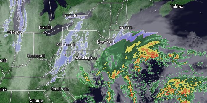
The word on the street is it might snow this week. Just in case you have lived under a rock this weekend, you should probably know that a major, possibly historic, snowstorm is heading for the Northeastern United States. It’s possible some of the worst conditions will be in Southeastern New England as the storm pummels the area with heavy snow and strong winds that could lead to blizzard conditions Monday night into Tuesday. We’ll summarize the storm impacts and timing below.

TIMING
It will be mostly cloudy with scattered snow showers possible through midday Monday. The leading edge of steadier snow will likely arrive from south to north during the afternoon. It will most likely be snowing during the evening commute in Rhode Island and Southeastern Massachusetts. 1-2″ of snow is possible by 7 pm in this area.
The snow will become moderate then heavy at times Monday night into early Tuesday. This will be the height of the storm as far as snowfall rates are concerned. 1-2″ per hour bands will develop, and it’s possible there could be 2-3″ per hour snowfall rates in localized areas. It is impossible to know exactly where those bands will set up, and snowfall totals may vary by several inches over a span of 10-15 miles.
The temperature will fall from near 30 to the upper teens to low 20s by early Tuesday morning in most of RI. There is likely to be a stark contrast (coastal front) that separates the upper teens from the low 30s over another relatively small area. The placement of this coastal front is important in determining where the heavy snow bands happen – usually northwest of the front.
There may also be a difference in snow consistency on either side of the front. The warmer side of the front will have a wetter, pasty snow, and the colder side will be dry and fluffy. You may remember that there was a wet and heavy snow early in the February Blizzard of 2013 before colder weather arrived and it became dry and powdery. The wet and heavy snow clung to and then froze on trees, and that led to widespread power outages when the strongest winds kicked in.
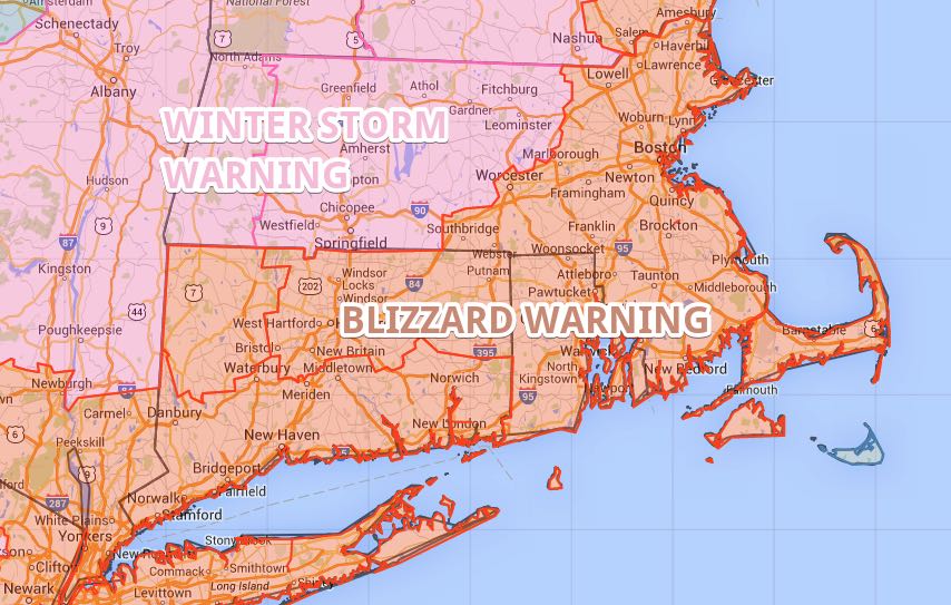
The wind may peak late Monday night or Tuesday morning, and that is the best chance of the National Weather Service Blizzard Warning verifying. Heavy snow early Tuesday will give way to light to moderate snow bands during the day on Tuesday – especially in the afternoon. Snow may still accumulate, but not at the rate that it did earlier in the storm. There will likely be 10-18″ of snow on the ground by dawn on Tuesday, and travel is not advised Tuesday morning. The winds will be howling, and there will be lots of blowing and drifting. The temperature will be in the teens to 20s during the day on Tuesday.
Peak Wind Gust Potential
Cape Cod / Islands – 65-75 mph
Buzzards Bay and Rhode Island Coast – 55-65 mph
Rest of RI and interior SE MA – 50-60 mph
Occasional snow will continue into Tuesday night as the storm slowly drifts east of New England. Snow will end from west to east early Wednesday. It will be a partly to mostly cloudy and blustery day. Highs will be in the 20s, with wind chills in the single digits to teens thanks to a 15-30 mph wind.
Snow Totals
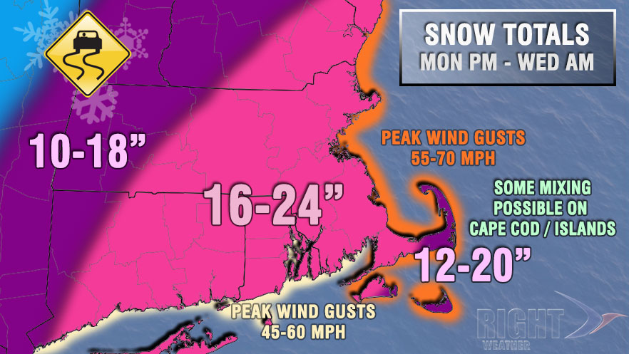
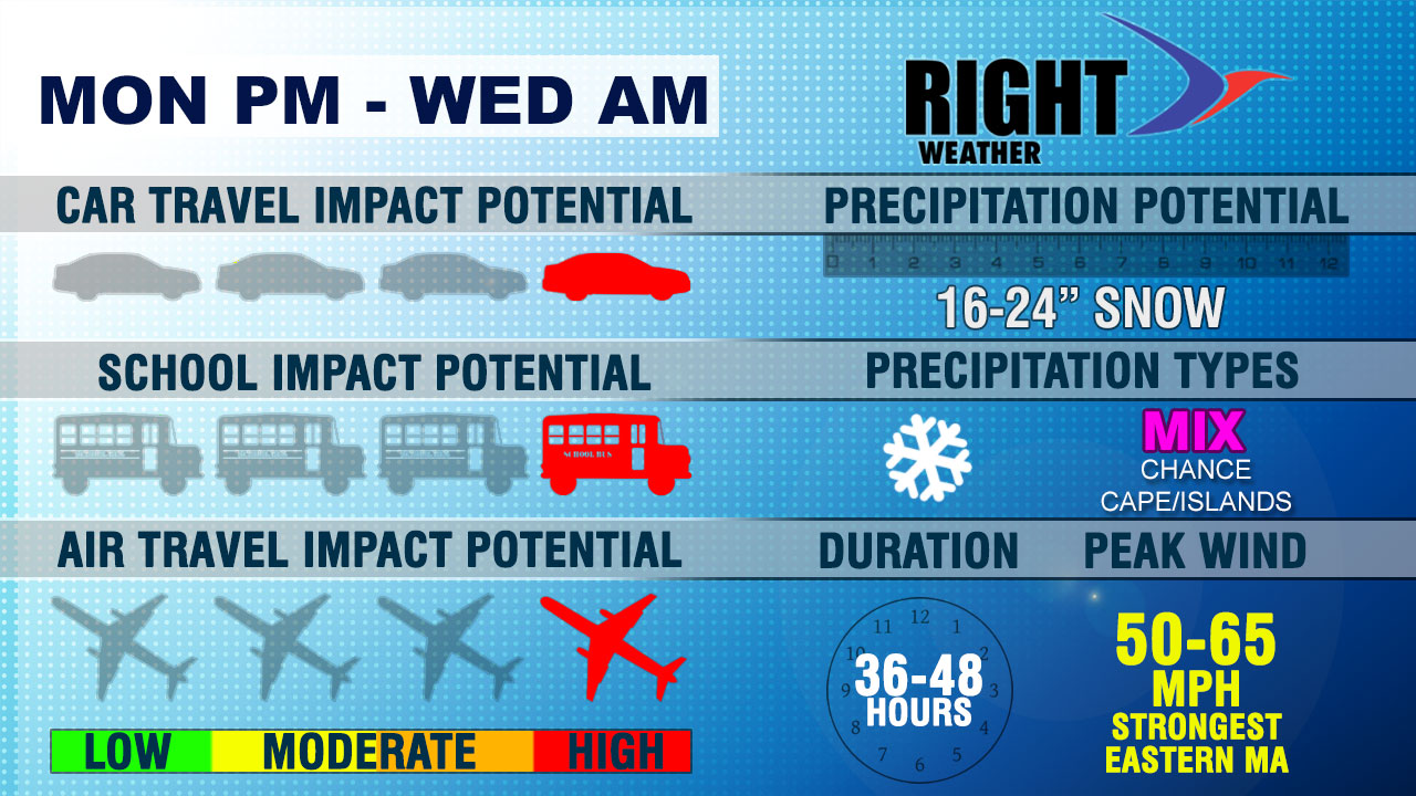
As you can see, we are expecting a widespread 16-24″ storm – on par with the snow totals from the February 2013 Blizzard. It’s possible that there will be localized higher amounts because of the intense bands that setup Monday night. This storm has a good chance of being a top-10 snowstorm on record in the Providence area, and, in a worst-case scenario, it could make a run at the Blizzard of 1978 for the top of charts at 28.6″. We think it’s likely to fall short of that historic storm, but there have only been three storms over 19″ since 1905.
Power Outages
We cannot predict if your area will lose power, but a storm this strong producing more than a 18″ of snow and 50 mph winds will certainly lead to some down trees and power lines. You should have a plan in place for if you lose power. Outages were widespread, and in some cases long-lasting, during the February 2013 Blizzard.
School/Work Cancellations
It is also tough for us to predict how school districts will handle the storm, and there could be residual impacts like power outages that keep schools closed after the snow has ended. It is highly unlikely that there will be school on Tuesday. In fact, there may be a State of Emergency in effect if the storm delivers on its potential. Even though the snow will end early Wednesday, there could still be travel and safety issues for some school districts where snow banks are piled high near bus stops, streets are not plowed, or students face a longer commute. It’s possible some schools will be closed through the midweek.


