
A fast-moving weather system will bring a plowable snow to most of Southern New England Sunday night. The storm will slow travel Sunday evening, but it should end in time for main roads and highways to be cleared before the Monday morning commute. The trip to work and school is likely to be a little slower than normal, but not treacherous. Check out the impacts graphic below for our forecast on how the storm will affect air and car travel, schools, and more.
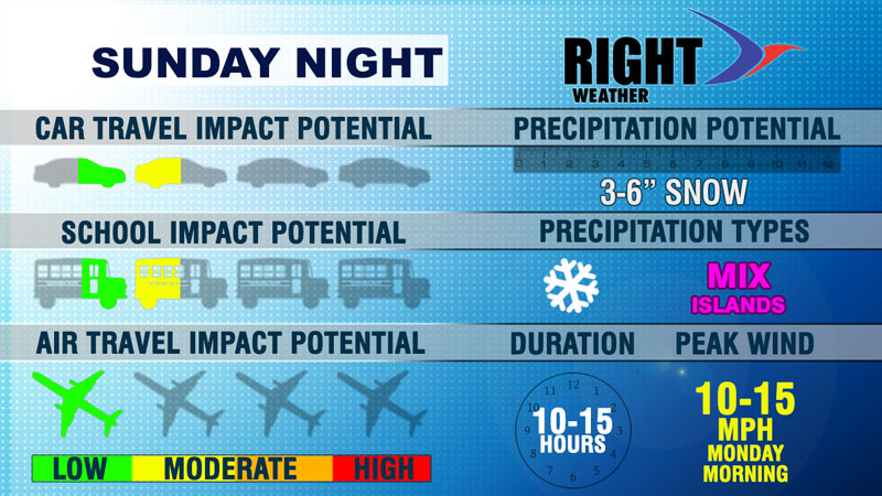
CAR TRAVEL IMPACT POTENTIAL
The main impact on the roads will be from Sunday evening until before dawn on Monday. With a few inches of snow expected, there are likely to be snow-covered roads. The timing of the storm will likely allow plow crews at least a couple of hours to work on the roads before the morning commute. There will not be much residual impact on Monday morning as the temperature rises into the 30s with sunshine.
SCHOOL IMPACT POTENTIAL
It is always tough to predict how school systems will handle snow events. At this point in the year, school administrators are hoping to not have to use any more snow days this winter. Based on the timing of the snow, there should not be widespread school cancellations, but some delays are possible. We had a 2-5″ snow event in the middle of last week that had little impact on schools, with just a few 1-hour delays near the coast.
AIR TRAVEL IMPACT POTENTIAL
A few flights Sunday evening may be altered because of the snow in the Northeast. Otherwise, air travel should be normal on Monday morning as the storm moves swiftly out to sea
WIND AND DURATION
The storm is a fast-mover without much of a wind impact. The wind will be light during the storm, and may increase to 10-20 mph as the storm moves away Monday morning.


