The very cool and damp weather pattern will ease late in the weekend, and nice weather is ahead for most of next week.
SATURDAY NIGHT
It will be cloudy and somewhat damp, with patchy mist and drizzle, and lows in the upper 40s to low 50s. The breeze will stay active out of the northeast between 10-25 mph.
SUNDAY
It looks like a mostly cloudy day, with a patchy drizzle possible. It will not be as chilly, with the temperature slowly climbing to near 60 in the afternoon. The 10-25 mph northeast breeze continues.
MONDAY
Look for a blend of clouds and sunshine. It will be breezy and seasonably cool. Highs will be in the low to mid 60s.

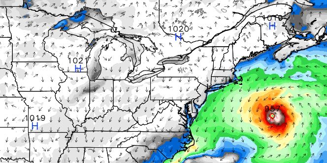
MIDWEEK
Tuesday will be a decent day as Joaquin moves further away from the United States into the North Atlantic Ocean. It will be partly to mostly sunny with highs in the upper 60s. The northeast wind will finally begin to relax. Lows will be in the low to mid 40s early Tuesday morning. Wednesday will be another nice day. You can expect highs in the upper 60s to low 70s under mostly sunny skies. There will be a cooler wind direction Thursday and Friday. Highs will be in the 60s with lows in the 40s both days. It looks dry until at least Friday afternoon when a few showers could threaten from the west.


