Most of the upcoming week looks dry, and there will be a big warm-up in the midweek. It’s uncertain if the warm weather will hang on through the Memorial Day weekend. A nearby front may bring periodically cooler weather and a few showers from late in the workweek through part of the Memorial Day weekend.
MONDAY
Look for partly sunny skies with highs in the mid 60s to low 70s. A spotty afternoon shower cannot be ruled out, but odds are it stays dry. There is a better chance of rain between midnight and early Tuesday morning. Lows will be in the 50s.
TUESDAY
Early showers will give way to drier weather during the day. Skies may become partly cloudy in the afternoon. Highs will be in the mid 60s.
WEDNESDAY
Warm weather pounces on Southeastern New England when mostly sunny skies return on Wednesday. Highs will be in the low 80s inland, and 70s at the coast.
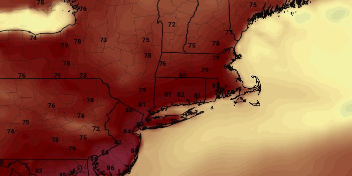
THURSDAY
It will stay warm on Thursday with highs ranging from the 70s at the coast to the mid 80s inland. Clouds increase Thursday night ahead of a shower threat for Friday.
FRIDAY
A nearby front will likely bring more clouds and scattered showers on Friday. Highs will be in the 60s to low 70s. It does not look like an all-day washout.
WEEKEND
The Memorial Day weekend will be a close call between unsettled weather and a preview of summer warmth. The wind direction is very important in determining whether temperatures are in the 80s with sunshine or 60s/70s with clouds and showers. It’s too early to say exactly where the front will be that determines the wind direction and later weather. It looks like Saturday will be warm, with a better chance of showers on Sunday and Monday, but that could change as the pattern evolves.


