Hurricane Dorian is hammering the Carolinas on Thursday as it begins a turn to the northeast that will shoot it out to sea south of Nantucket early this weekend. As expected, the storm is bringing heavier rain and stronger wind to the Carolinas than it did to Florida. Hurricane wind conditions are possible at the coast of South and North Carolina. Myrtle Beach has already received more than 5″ of rain and some coastal towns could get upwards of 12″ before the storm moves away.
Dorian impact in Southern New England

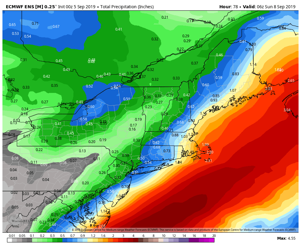
There will be an impact from Dorian in Southern New England. Like a coastal Nor’easter, the greatest wind impact will be near the ocean – particularly on Nantucket. In general, the heaviest rain will also be over Southeastern Massachusetts, but there could be a relatively heavy band of rain over northern CT western/central MA. Widespread flooding from Dorian is unlikely due to rainfall in Southern New England. The best chance of getting more than 2″ of rain is on Cape Cod and the Islands. Most other cities/towns in CT, RI and SE MA will likely be closer to an inch of rain.
Gusty wind early Saturday

Dorian should come close enough to bring wind gusts over 30 mph to all of Southeastern New England. There is a chance for a few 50 mph gusts not far from the RI coast and Buzzards Bay. Nantucket could see a gust over 60 mph. For the most part, the wind should not be strong enough to cause widespread damage, but with foliage still on the trees, some coastal areas could see some downed branches or diseased trees. The peak winds are likely between 5-10 am Saturday.
Dorian will also bring big swells and rough surf to the Southern New England coast. Expect dangerous rip currents on Saturday – although it does not look like much of a beach day!
Day-by-day forecast
Thursday: Becoming partly to mostly sunny. Not humid. Highs in the low to mid 70s.
Thursday night: Mainly clear, lows in the low to mid 50s.
Friday: Clouds increase, showers likely in the afternoon. Becoming breezy. Highs in in the upper 60s. ENE wind 10-20 mph.
Friday night: Rain likely, may be heavy at times. Gusty wind. Lows in the 50s. NE/N wind 10-25 mph, with 25-40 mph gusts
Saturday: Wet and windy early. Rain ends by mid to late morning. Breeze diminishes in the afternoon. Highs in the upper 60s with some afternoon sun. N/NW wind 15-30 mph with gusts 30-40 mph (stronger SE MA) in the morning. 10-20 mph in the afternoon.
Sunday: Mostly sunny, highs in the low to mid 70s.
Early next week: Looks dry and pleasant through at least Tuesday. Highs near 70, lows in the 40s/50s.
Turn off the A/C (for good?)
Wednesday’s thunderstorms represented the leading edge of refreshing air that is arriving Thursday morning. Looking at the long-range forecast, I do not see any hot/humid weather on the horizon, and there’s a reasonable chance that air conditioners will be getting a break for a while – possibly until next spring. There may not be an extended stretch of highs in the 80s or lows in the 60s ahead of us for the rest of the month and into October. A one or two day bout of 80s/60s, may not be enough to warm the house enough to warrant the A/C.


