MIDNIGHT UPDATE
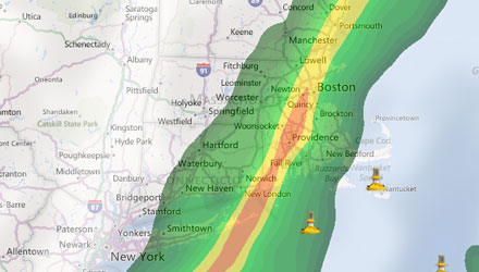
The storm was progressing as expected. The strongest winds should move through RI by 2 am, with some heavy rain continuing through the night. The strongest winds will move through SE MA by 4-5 am. Many areas will pick up more than an inch of rain, and those hardest hit, which may well be in the Providence area, could see 2+”
Showers will linger for the early morning commute, but by 7-8 am we should begin to see drier air move in. The weather looks decent for most of Wednesday, with a dry northwest breeze of 10-20 mph. The high will be in the low 70s.
FROM 7PM
The wind is already whistling, but the worst weather is not expected to come through until near or after midnight. A fierce squall line is moving through the Mid-Atlantic, and it will most likely not weaken much as it moves through Southern New England later tonight.
A Tornado Watch is in effect for Western New England and the Mid-Atlantic. Although a tornado can’t be ruled out in RI or SE MA, the main threat will be for powerful straight-line winds that could take down some branches and power lines.
The heaviest rain, with the chance of t-storms, should arrive around midnight in RI, and last for 2-3 hours in any given location. Rainfall totals between 0.75″ and 1.5″ are likely in most places. The rain should be winding down during the Wednesday morning commute, and we’ll see relatively quiet weather by mid-morning.
Peak wind gusts for most will be around 45-50 mph, but a few places may see gusts of 55-60 mph. The strongest winds will be just before or during the heaviest rain. So, for most of us, that is between 11pm and 5am – a little later in SE MA.
Minor coastal flooding is likely at the time of high tide Tuesday night. Most will see a 1-2 ft. storm surge – not enough to cause major problems.
