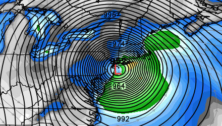
As a meteorologist, it is never a good idea to overreact to a single computer model run. We usually try to look for trends over a period of several model runs. With Sandy being so large and dangerous, however, I think it is worthwhile to give a quick analysis of the 00z GFS Model that arrived Friday evening. There are some significant changes between this computer model simulation and prior runs of the GFS and other models. First, the track is more northerly and direct to the Northeast coast. As a result, the storm arrives 12 hours earlier than most models are projecting, with landfall on Monday evening instead of early Tuesday . The more northerly track also changes the approach angle slightly, which would likely have a difference with the wind direction and storm surge impacts at Southern New England coast.
It is quite possible that this computer model projection will not be completely accurate regarding Sandy’s track and intensity. The purpose of this analysis is to give you a better understanding of what the different projected tracks mean for Southern New England.
Check out the video below for Fred Campagna’s analysis of the Saturday 00Z GFS model.
Keep in mind, this is not a Right Weather forecast for the storm. It is an analysis of how this particular computer model run would impact Southern New England if it verified.
