

A fast-moving and rapidly intensifying storm will scoot by Southern New England this weekend sending a swath of light to moderate accumulating snow across RI, MA, and CT. There will likely not be enough cold air at the onset on Cape Cod due to the 40°+ ocean, but a transition from rain to snow is likely during the storm. The wind will be gusty out of the northeast Saturday night on Cape Cod, but not as strong as it has been for the past two storms (last Friday / Wednesday) in SNE.
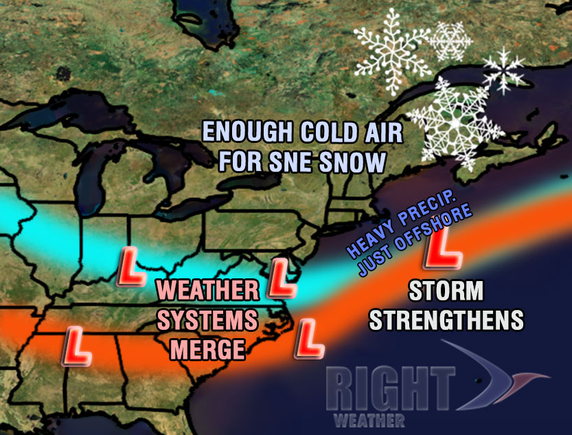
The storm will be rapidly developing as it passes southeast of Nantucket Saturday night. It will also be moving steadily along, so only a 12-18 hour period of precipitation is expected as the storm scoots by. The system is the combination of the two disturbances phasing together and creating a larger, stronger storm. If the intensification happens a little sooner and a bit farther north, than the impact in Southern New England could be greater. Right now, it looks like the heavy precipitation stays just offshore.
Forecast Details
The weather will stay quiet through Friday night as clouds increase in advance of the storm. Expect the wind to relax by late at night. The temperature will drop into the mid to upper 20s.
Clouds will continue to thicken Saturday morning as the wind swings around to the east-northeast and starts to slowly increase. Precipitation should arrive right around midday. It will be all snow away from the coast, but within a couple of miles of the coast, and on all of the Cape/Islands, the precipitation may start as a period of chilly rain and/or sleet.
- See the full storm timeline from start to finish
- See the updated snow odds for the Providence area
- The National Weather Service has issues a Winter Storm Watch for part of SNE
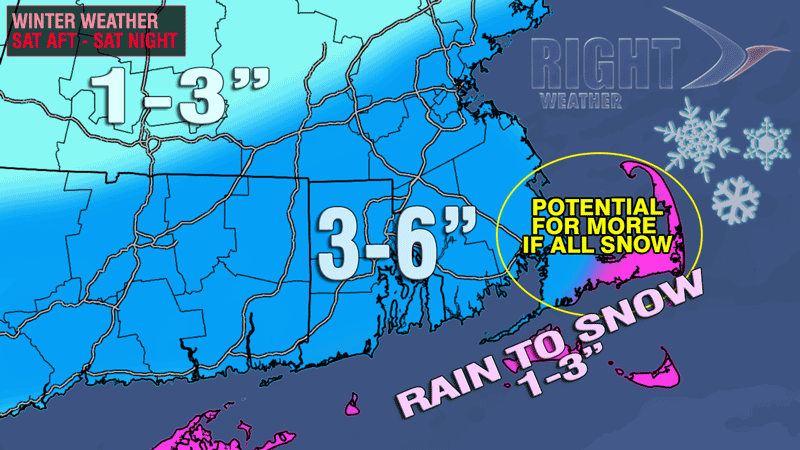
Light to moderate snow (and a mix on Cape Cod) will continue to fall in Southern New England through the afternoon and evening. The steadiest snow is likely during the evening. A gradual transition from rain/mix to snow is likely on Cape Cod late in the evening or after midnight. The snow should taper off in RI by dawn Sunday, and in SE MA by mid-morning.
Based on the current forecast track of the storm, the final snow totals will not be huge for most of the area, but roads will need to be treated and cleared, and you’ll probably have to shovel your driveway. If the storm tracks 50 miles farther northwest and/or moves just a bit slower, then the snowfall totals will nearly double throughout the entire area. That scenario is still possible.
The weather behind the departing storm will be blustery and very cold on Sunday. Highs will be in the mid to upper 20s, and the wind chill will be in the teens. The sky will become partly sunny. It will be mainly clear and bitter cold Sunday night. Lows will be in the teens on Monday morning.
Cold start to the New Year
Right now, it looks like there will be some chilly weather to ring in the New Year in the Northeast. The high on Monday will be in the low 30s, and the temperature at midnight will be in the 20s. Polar bears and penguins will have temperatures in the 20s, with a fresh westerly breeze for their plunges on New Year’s morning. An Arctic cold front will move through Tuesday or Wednesday, bringing in the coldest air of season as the kids head back to school for the rest of the week. When the Arctic air hits, lows will be in the single digits, and highs will only be in the teens/20s. The weather should stay mainly dry through the end of the week.
[/signoff]