


The first half of 2012 was relatively benign in Southern New England. There were very few, if any, major weather events, and the first several months of the year were highlighted by very warm weather. The second half of the year saw several wild weather events, including one of the biggest weather disasters to hit the Northeast in decades.
January-February: Where’s winter?
The winter of 2011-2012 was the second warmest on record for all of New England, except Maine where it was the third warmest. The temperature in Providence, RI averaged more than 4° warmer than normal in December, January, and February. There was also a noticeable lack of snow, with Providence totaling a mere 17.8″ for the entire season, 16″ shy of the normal. The total in Boston was 9.1″, barely missing the record for least-snowy winter (9″) set in 1936-37. The snow drought wasn’t as pronounced in interior Southern New England, with most areas receiving 60-65% of the normal amount of snow.

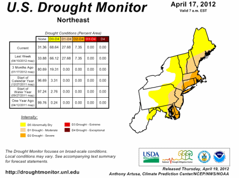
February-Mid-April: A mini drought
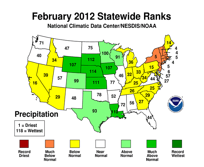
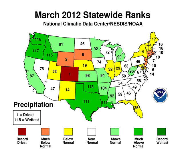
The very warm weather continued in March. In fact, it was the warmest March on record in Rhode Island and many other spots in the Eastern United States. Spring arrived with some summer-like weather in Southern New England. The high temperature was above 70° for a five-day stretch from March 19-23, with the mercury peaking at 81° on March 22. The warm weather was accompanied by a noticeable lack of precipitation. February and March were both in the top-10 driest on record in Southern New England. 30-35% of the normal precipitation fell in those months and a severe drought developed for most of Southern New England by mid-April. Thankfully, beneficial rain arrived on April 22, with more than 3″ falling in two days in the Providence area. The rainfall pattern has been close to normal since then, and, for the year, Providence has received about 87% of the normal precipitation.

August 10 – A first for Block Island
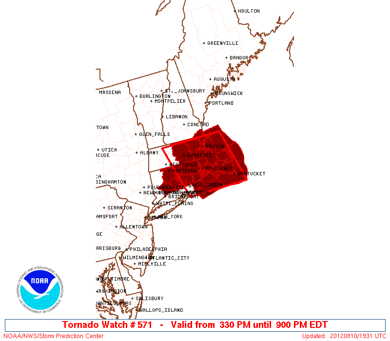
Severe weather and tornadoes are certainly not unheard of events in the summer in Southern New England, but, Block Island is normally not associated with the strongest storms because of its proximity to the ocean which can be a limiting factor on severe weather development. On August 10, however, a line of strong storms moved from CT and Long Island to RI and SE MA, and a confirmed tornado touched down on Block Island. It was the first confirmed tornado in the history of Block Island. It was also the first live broadcast on rightweather.net, and we were closely monitoring the rotation of that storm as it crossed Block Island Sound heading for Narragansett. Here is the NWS report on the storm:
...SUMMARY...
THE NATIONAL WEATHER SERVICE IN TAUNTON MA HAS CONFIRMED A
TORNADO ON BLOCK ISLAND IN WASHINGTON COUNTY RHODE ISLAND FROM
BACK ON AUGUST 10 2012.

NOTABLY...THIS IS THE FIRST RECORDED TOUCHDOWN OF A TORNADO ON THE
RECORD BOOKS FOR BLOCK ISLAND.

A TORNADIC WATERSPOUT OVER THE WATERS SOUTH OF BLOCK ISLAND MOVED
NORTHWARD ONTO LAND AS A TORNADO OVER THE SOUTHERN PORTION OF THE
ISLAND AROUND 354 PM. ON LAKESIDE DRIVE THERE WERE A COUPLE OF
FELLED TREES. DECK FURNITURE WAS THROWN 100 YARDS AWAY. SCREENS
WERE BLOWN OFF A HOUSE. DAMAGE TO AN ANEMOMETER OCCURRED AT A HOME
ON SAND`S POND ROAD. THERE WAS ALSO A REPORT OF 50 TREES BLOWN
DOWN ON A FARM.
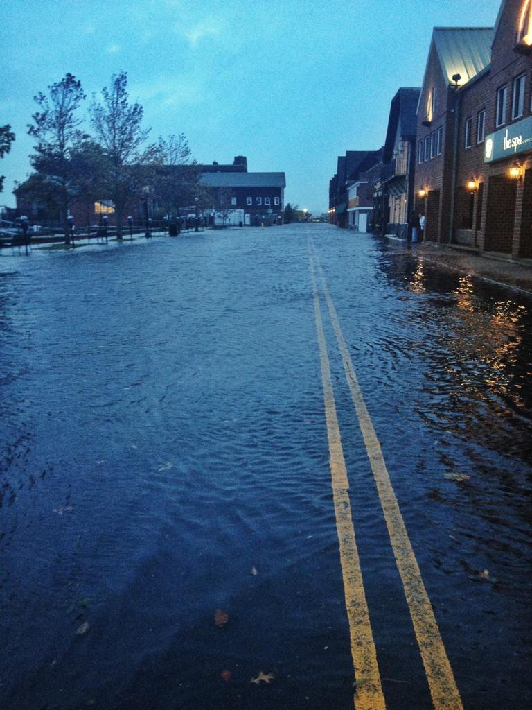
September 5 – Fall River under water
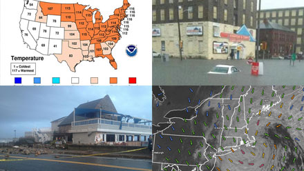
The remnants of Hurricane Isaac moved through Southern New England on September 5 bringing torrential rain and flash flooding to Bristol County MA and RI. The hardest hit city was Fall River, where many areas were inundated after 4-5″ of rain fell in the morning, leading to severe flooding by noon. Cars were submerged and people had to be rescued from the rising water.
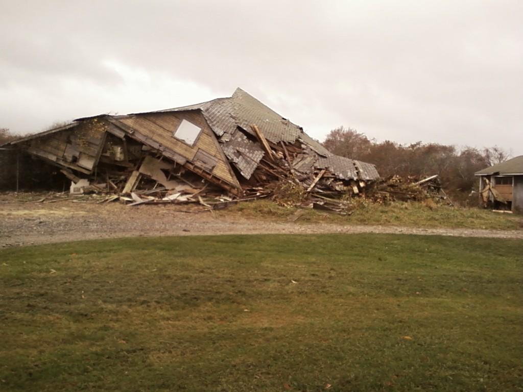
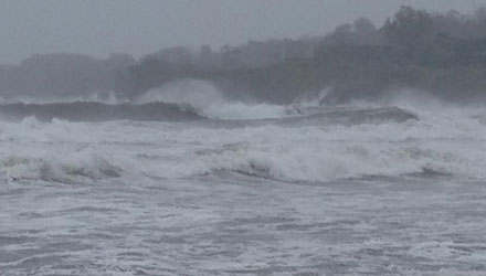
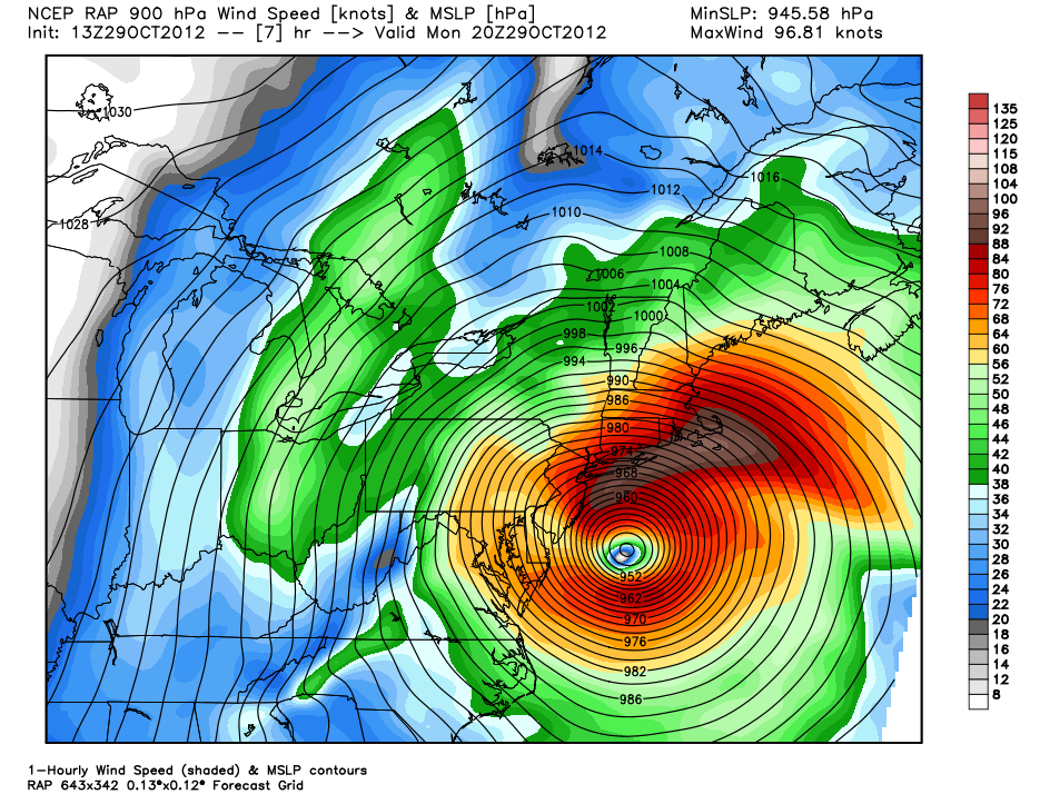
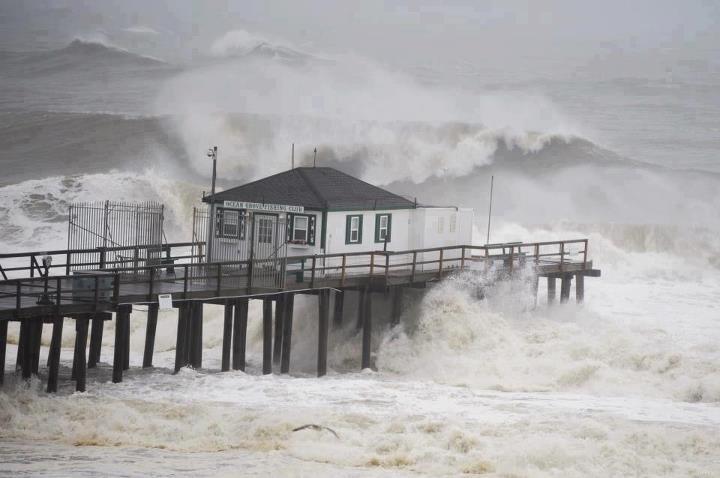
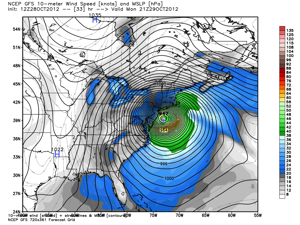
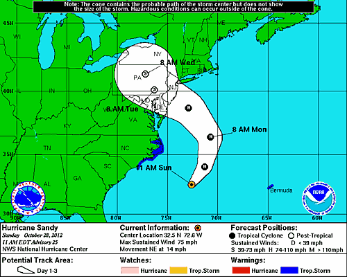
October 29 – Hurricane Sandy
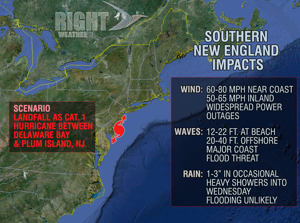
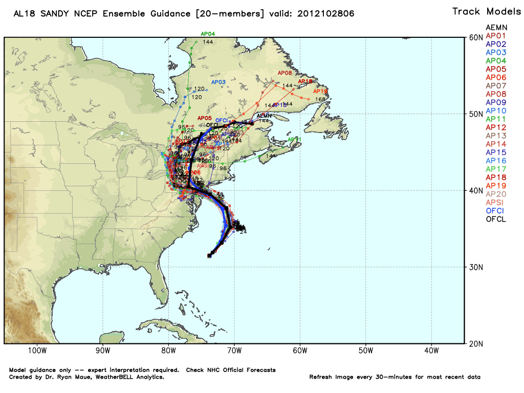
Without a doubt, the biggest weather event in Southern New England in 2012 was Hurricane Sandy. It was probably the biggest weather event to occur this century, and was the most destructive hurricane to impact Southern New England since Hurricane Bob in 1991 – even though it made landfall south of Atlantic City, NJ. The storm, which was remarkably well forecasted by the computer models and National Hurricane Center (except for that part about not issuing hurricane warnings), brought a significant storm surge to the coast of RI and CT. Severe damage occurred in South County, including the destruction of the Coast Guard House restaurant in Narragansett. Peak wind gusts reached hurricane forecast at the south coast, and, at the height of the storm, 1.1 million Southern New Englanders were without power. The damage from Sandy was even worse in New Jersey and New York, where it will go into the books as one of the all-time great natural disasters. It will take months or years before some portions of coastal New Jersey can recover from the devastating effects of the storm surge and powerful winds.


November 8 – Insult to injury, another early-season Nor’easter
Less than 10 days after Hurricane Sandy, a rare early-season Nor’easter pounded the Mid-Atlantic and New England. Heavy, wet snow fell in inland locations, with 9″ reported in Western CT and Central MA. As much as 5″ of heavy, wet snow fell in NW RI. The wind reached 70 mph near the coast. The long duration of the storm meant another battering for the shoreline already significantly weakened by Sandy’s wrath.
While there was not an inordinate number of extreme weather events in Southern New England in 2012, those that did strike had a high impact. There is no way to know exactly what’s ahead for 2013, but, odds are, we’ll have plenty of wild weather to remember at the end of the year.