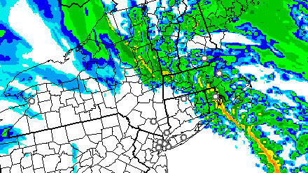
Winter arrived at 6:12 am and the world did not end as some had feared. The weather, however, is wild in the Northeastern United States as a powerful storm that brought a blizzard and tornadoes to different parts of the country roared up the Appalachians. Moderate to heavy showers are likely until about 3pm in CT, RI and SE MA. The rain is moving west to east, so it should wind down in CT by shortly after noon, in RI by about 2pm, and by 3pm on Cape Cod. Rainfall totals of 0.5 to 1.5 inches are likely. The rain will be accompanied by howling winds, and some 50+ mph gusts are possible – especially near the coast. The strongest winds should coincided with the heaviest rain, with the greatest threat of damaging wind in CT until about noon, RI between 10am-1pm, and SE MA from 11am-2pm.
The wind will shift from the SE to the SW as the cold front passes in the early to mid afternoon. Although breezy, the wind that wraps around the storm will not be nearly as strong as the winds ahead of the cold front. Colder air will immediately start to move into Southern New England behind the front. The temperature will fall from highs in the upper 40s to mid 50s to the low to mid 40s by late in the day. A few rain showers are possible through early Friday evening. The temperature will continue to tumble into the low to mid 30s by dawn Saturday. Scattered light showers and flurries will hang around through Saturday, with highs in the upper 30s to low 40s.
The weather will be fairly quiet Sunday and Christmas Eve. Highs will be in the upper 30s, lows in the mid 20s. Skies will be partly cloudy to mainly clear. A fast-moving system may bring some light snow and/or rain to Southern New England. from late Christmas Eve into Christmas Day. Right now, it looks like the best chance of accumulating snow is away from the coast.
[/signoff]