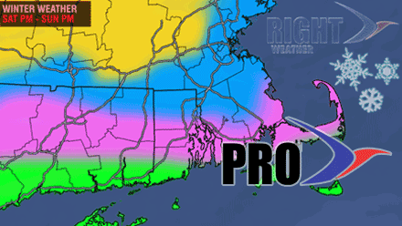
This is the third straight weekend that Southern New England will be dealing with a winter storm. The forecast for each storm has gotten progressively more difficult. The blizzard two weeks ago was fairly straight forward – most of SNE was going to get bombed! Last week was tough because of the uncertain track of the storm. This week is particularly tough because of the uncertainty regarding the track and the precipitation type in CT, RI, and SE MA.
We always like to give the Pro subscribers a first look at the accumulation map, and, this time, we have waited until the last possible minute to put it out there. Unfortunately, even though we’ve waited to issue it, there is less confidence in this snow forecast than any other we have issued all winter. Here’s why:
- While the models are pretty adamant about there being predominantly rain/mix from the coast to Hartford, Providence, and possibly Boston, Saturday night, their margin for error is very slim. A slight shift south in the storm’s track may be just enough to turn a half inch of forecasted rain into 4-6″ of heavy, wet snow. By the way, most models are predicting about an inch of rain Saturday night before any changeover, which just ups the ante.
- The models also give a significant amount of wraparound snow with this storm. It is highly unusual to see such heavy rain followed by a half foot or more of snow. Our feeling is that the snow on the back side will not be as big a factor as some models are indicating.
- When looking at the map below, we’re most confident in the gold and green shaded areas, with the most uncertainty on the line between the pink and blue areas.
- This is definitely a forecast to keep an eye on if you have plans that may be impacted by the weather Saturday night or Sunday
