The awesome, active weather pattern that has dominated the Northeast United States for the better part of February will be continuing for the rest of the month. TF Green has received nearly 20″ of snow so far this month, and the active pattern could have it threatening the February record snowfall of 30.9″ set in 1962.
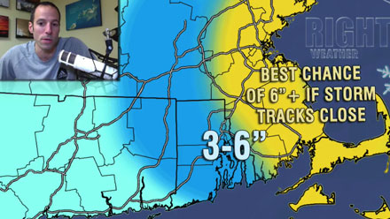
In the near term, the focus is on the evolution of an ocean storm. This one will either be chalked up as another hit or a major missed opportunity by snow-lovers. The jet stream pattern is favorable for an East Coast storm, but it may form just far enough offshore to spare Southern New England from anything more than a few inches of snow from late Friday night through midday Sunday. If the storm backs in, which I suspect it will, then parts of Southeastern New England may receive more than 6″ with some gusty wind thrown into the mix, too. In a worst-case scenario, there will be near-blizzard conditions in E MA late Saturday night and/or Sunday morning. The accumulation map is available in the latest update on the free part of rightweather.net
Looking ahead to next week, the storm that will arrive Tuesday night will likely not be potent, and may be snow/mix/rain as the colder air hangs on while the storm redevelops over PA and moves over or just south of Southern New England. It doesn’t look like a major event, either way. Later in the week, another storm will traverse the country and threaten SNE with some snow. The timing of that system is Friday and/or Saturday.
Overall, the active weather pattern will continue through the end of the month, and, spurred on by a very cold blast Sunday into Monday, the temperature should average below normal for the next two weeks. Now, if we can just get to that snow record!
