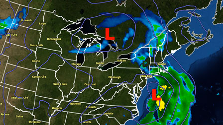
Snow inland and snow/rain near the coast early Saturday evening will gradually transition to mainly rain from south to north. The steadiest precipitation will move through by around midnight, with some lighter rain or mixed precipitation likely after midnight. The temperature will be in the mid 30s near the coast, and low to mid 30s inland. Minor accumulation, without much impact on treated roads, is possible away from the coast.
Some snow/rain Sunday into Sunday night
Snow showers Sunday night could lead to an inch or two in RI and SE MA. It all depends on how the disturbance connecting the two weather systems is positioned. It is possible that the steadiest snow stays north and east of RI. The temperature will fall into the upper 20s by Monday morning. Some slick spots are possible on untreated surfaces late Sunday night and Monday morning.
Active weather pattern into early-March
There will be a break in the weather action Monday through Tuesday. Both days should feature some sunshine and highs in the low 40s and lows in the mid to upper 20s. An extended stretch of unsettled weather is possible from Wednesday through the end of the week. Initially, it should be warm enough for rain, but as the week progresses, another storm may form in the Atlantic Ocean. The details are vague, but it is a weather pattern that could lead to a stubborn storm not far from the Northeast coast in the first week of March. For now, expect rain on Wednesday with temperatures in the 40s, and a chance of showers on Thursday, with highs again in the 40s.
