A potentially volatile weather situation is developing along the Eastern Seaboard Saturday afternoon. A storm will rapidly develop off the Carolina coast and head to the north-northeast passing east of Nantucket Sunday morning. Snow was breaking out along a stalled Arctic front that will serve as the focus for storm’s track and subsequent accumulating snow. The storm’s impact will be greatest in far Eastern New England (Cape Cod / Nantucket), but it should deliver another round of plowable, fluffy snow to E CT, all of RI and interior SE MA as well. This is a lengthy update, and the accumulation map is on the next page.


- Download the FREE RightWX app for your Android or iOS device right now
- National Weather Service issues Winter Storm Warning
- National Weather Service issues High Wind Warning for Cape/Islands
Storm timeline – worst Sunday morning
Occasional light to moderate snow will continue into Saturday evening in Southern New England. Surface temperatures will be at or above freezing through sunset, so widespread accumulation and hazardous travel is not expected during this time. As the sun sets and the wind picks up out of the north, the temperature will drop into the 20s, and there is a better chance of the snow sticking on the roads. Initially, most of the snow will come as a result of a stalled front just south of Southern New England. Any heavier snow late Saturday night and Sunday will be directly connected to the rapidly developing storm as it moves north.

The height of this storm will likely occur Sunday morning. Strong, gusty winds and a period of moderate to heavy snow is possible from RI through SE MA, with the highest likelihood of the heavier snow and strongest winds on Cape Cod and the islands. As the storm passes Cape Cod around midday Sunday, the snow should begin to wind down from west to east. The temperature will continue to fall late Saturday night and Sunday, and the snow will be very dry, fluffy, and prone to reducing visibility in the gusty winds. Temperatures will only be in the teens to mid 20s on Sunday, and wind chills will be near 0.

Storm impacts – highest in E MA
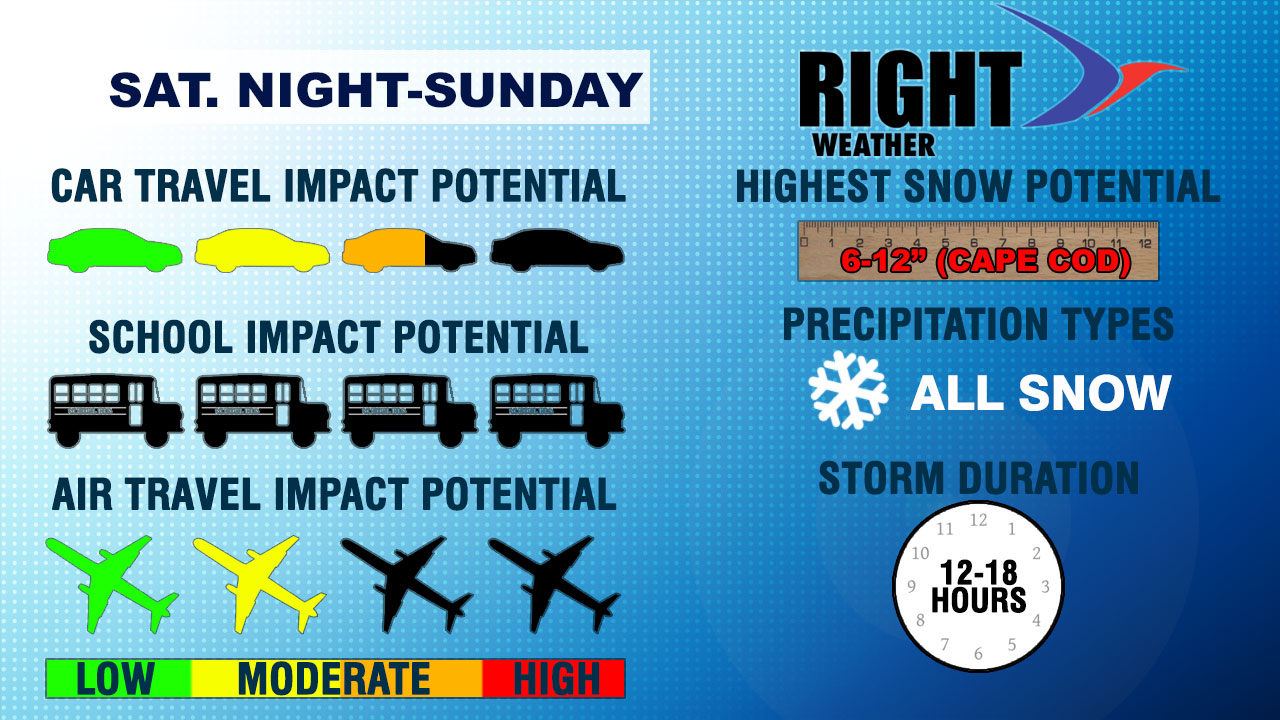
Overall, the storm will have a moderate impact on car travel. It should not be a huge factor for anyone heading out this evening, but some slick roads are possible after sunset. The biggest impact will be tomorrow morning, with the worst conditions on Cape Cod and the islands, where it could be a high-impact event with the strong winds and a period of heavy snow. If you’re planning on attending church services Sunday morning in RI or interior SE MA, the weather may be an issue. If the storm comes as close to Southern New England as some computer models are projecting, then there will be period of wind-driven snow from late Saturday night through Sunday morning.
There may be a brief, moderate impact on air travel from TF Green and Logan airports. Gusty winds and snow could impact some flights on Sunday. The storm has the potential to bring about a foot of snow to the hardest hit areas on Cape Cod. Odds are it will be lower than that, but it bears close watching. There is no question about precipitation type with this storm. It will be all snow. The brunt of the storm duration, even though there is some light snow occurring Saturday afternoon, will be between mid-evening Saturday and early Sunday afternoon.
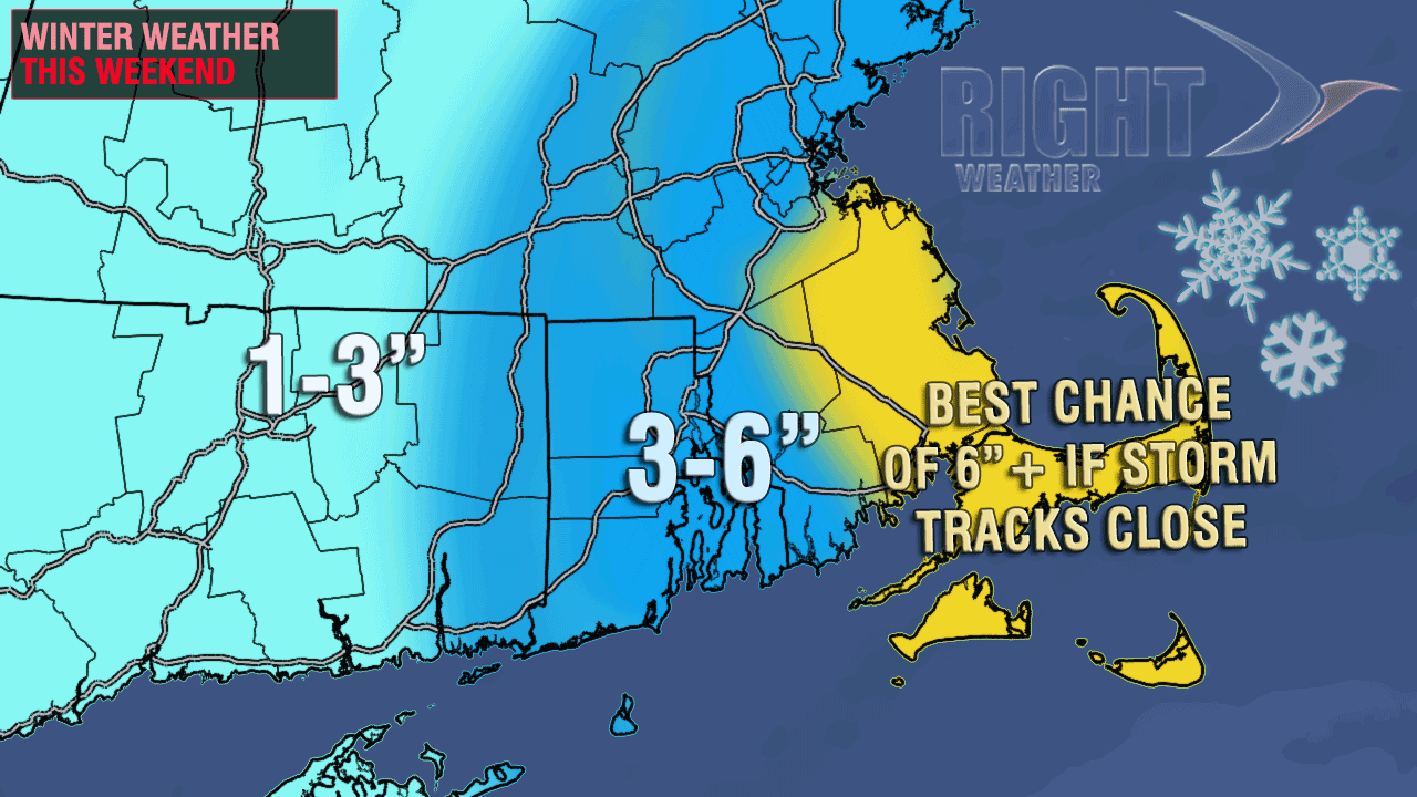
Snow totals – highest in E MA
The Right Weather accumulation map has not changed much in the past few days. It still looks like the impacts from the storm will increase as you head from west to east in Southern New England. It’s a moderate event in RI and interior SE MA, with the potential for bigger impacts from Buzzards Bay through Cape Cod and the islands. In fact, near-blizzard conditions are possible Sunday morning in those areas. While the snow totals will not be as high as the blizzard last week, the wind will be strong enough, and there could be some heavy snow bands that set up long enough for this storm to reach blizzard status somewhere in Eastern MA.