


There is a lot of uncertainty concerning the mid to late workweek forecast in Southern New England, but one thing is for sure – there will not be a big warm-up this week. Monday will be very similar to Sunday, with partly to mostly cloudy skies, a northwest breeze, and highs in the low 40s. The weather will stay mainly dry and cool on Tuesday. It will be partly cloudy with highs in the low to mid 40s as the wind swings around to the northeast.
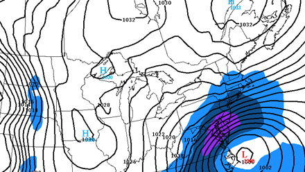
A storm that is likely to have a major impact in the Mid-Atlantic from Washington DC to Philadelphia will cause at least fringe effects to occur in Southern New England. The large storm will move into the Atlantic Ocean well south of Southern New England. It’s uncertain if the storm will turn far enough north to bring heavy or even steady precipitation to Southern New England, but it should be close enough for showery rain/snow, gusty winds, cool temperatures, and some rough surf.
- If the storm travels farther away from Southern New England, the peak wind gusts would be around 35 mph on Cape Cod, the precipitation will be light and spotty, and tides will not be high enough for widespread coastal flooding. Highs would be in the upper 30s to low 40s.
- If the storm travels closer to Southern New England, the peak wind gusts would be well over 50 mph near the coast, some moderate to heavy snow/rain would be likely, there would be a minor-moderate coastal flooding threat, and highs would be in the mid to upper 30s.
Obviously, there is quite a difference between the two scenarios, and it is still unclear which track the storm will take. Right now, most computer models favor the track that brings fringe effects instead of a direct hit. The timing of the storm is Wednesday through Thursday.
Looking ahead to next weekend, the storm should be far enough away by late Friday that the wind starts relaxing, but it’s unlikely that there will be a big warm-up. Friday will be in the 30s or 40s, and Saturday should be partly sunny, with highs in the low to mid 40s.