


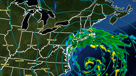
A storm that is leaving a trail of heavy snow from Western Canada through the Midwest to the Nation’s Capital is expected to move into the Atlantic Ocean on Wednesday and threaten Southern New England with heavy snow and rain, strong winds, and coastal flooding. The storm will not be short-lived, lasting from Wednesday afternoon through Thursday into Friday.
- TV station snow forecast roundup
- Computer Model Trends (Right Weather Pro)
- National Weather Service issues Winter Storm Watch
- Great interactive map for coastal flood watches/warnings


Download the free RightWX app for your iOS (iPhone/iPad) or Android device
Storm Impacts
Heavy snow
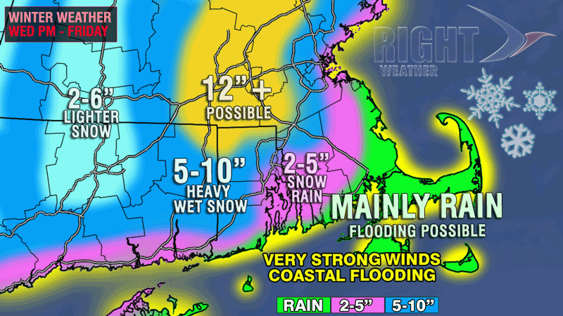
Any snow that falls will be of the wet and heavy variety that caused so many downed trees and power lines during the blizzard in early February. One difference between that storm and this one is that the snow actually froze to the trees in the blizzard as the storm progressed and that increased the likelihood of branches and power lines coming down. The hardest hit areas should receive a foot or more of snow that will be difficult to shovel.
The favored area for the heaviest snow is not too far northwest of the I-95 corridor. A slight shift in the temperature profile with this storm will bring the heaviest snow closer to the Providence and Boston. Another area to watch for heavy snow is actually in the I-95 corridor between Boston and Providence in Norfolk County, MA.
Closer to the coast, especially in SE MA, the precipitation is more likely to be rain than snow, especially after late Wednesday night. The coast of RI is a close call because there may be enough cold air around Wednesday night for a heavy, wet accumulation before the changeover Thursday morning. The precipitation should be mainly rain on Cape Cod and the islands.
Heavy rain
The areas that do not receive heavy snow in Southeastern New England have the potential to get more than 2″ of rain from this storm between late-Wednesday and Friday afternoon. While that is not enough to lead to flash flooding, area rivers and streams will be rising, and a high water table could lead to more wet basements – similar to what happened during the late-February soaker. Some areas may receive at least 6″ of snow followed by an inch or more of rain. That would lead to quite a mess, and snow clogged storm drains may contribute to big puddles on the roads.
More storm impacts on the next page including strong winds and coastal flooding.
Strong winds
The strongest winds will be near the coast. The peak gusts should not be as strong as they were during Sandy or the February 8-9 Blizzard. However, there is likely to be a prolonged period of strong sustained winds with higher gusts. Cape Cod may experience 30+ mph sustained winds, and 45+ mph gusts for 42-48 consecutive hours from late-Wednesday through Friday afternoon. Near Buzzards Bay, the RI coast, and the east coast of MA from Plymouth to the North Shore including Boston, winds are expected to be sustained over 25 mph, with 40-50 mph gusts in that same timeframe. This kind of long-duration wind event can eventually take its toll, and it would have a major impact on the utility crews’ ability to promptly restore power if there are outages due to heavy snow and/or wind Wednesday night.
Coastal flooding
Tides are not quite at their astronomical peak in the next few days, but a consistent strong wind from basically the same direction (northeast) combined with a large storm in the Atlantic Ocean will lead to coastal flooding and huge breaking waves that will cause beach erosion. Many area beaches have had a rough stretch with several powerful ocean storms in the past six months, beginning with Sandy in late-October. This storm should be strong enough to further change the coastline in some areas.
Everyday life impacts
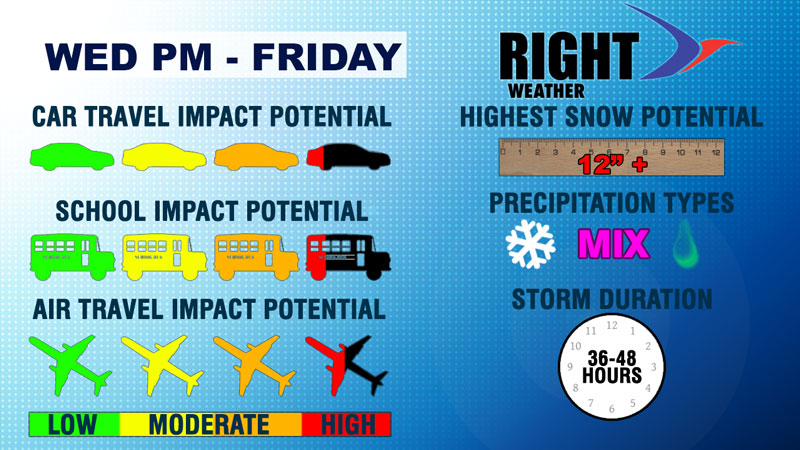
The storm is likely to be fairly disruptive and may lead to yet another snow day or two for some area schools. It’s possible school could be impacted both Thursday and Friday, with the best chance of the Friday impact coming well away from the coast. The roads should not be in as bad condition as they are during a mid-winter storm, especially during the day. The high sun angle and pre-treating should be enough to get to bare pavement on the major roads. At night, it could be a different story, especially in areas where the temperature falls to 32 degrees F or lower. The strong winds and driving rain near the coast on Thursday could make travel tough.
Air travel will most likely be impacted because the storm is expected to bring accumulating snow to most airports from Washington DC to Portland, ME. The combination of strong winds and heavy snow/rain could really slow things down at both Logan and TF Green.
Stay with rightweather.net for continuing coverage of this late-winter Nor’easter. Even at this late stage of the game, this forecast is still subject to change. There is a very fine line between an inch of rain and a foot of snow with late-winter storms, and the accumulation map may need to be adjusted in the next day or two.