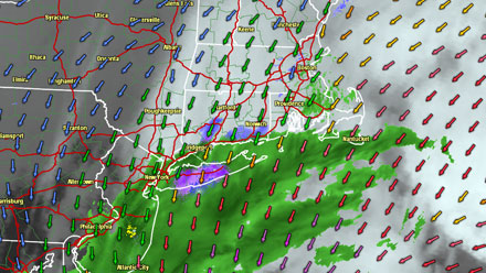
It’s late Wednesday evening, and the precipitation part of the Nor’easter is just about to begin in Southern New England. With any big storm there are always other plausible scenarios that don’t make it into the official forecast. In this case, there are two scenarios that are particularly concerning when it comes to the snow forecast for Southern New England.
1. It doesn’t snow much or the snow doesn’t accumulate well
This is always a great challenge with early and late season storms. The sun angle is high, temperatures are marginal (sometimes a few degrees above freezing), if it doesn’t come down moderate to heavy it won’t stick. This storm is interesting in that it should snow tonight and tomorrow night, so there are two shots at accumulating snow in many spots away from the coast. RI and SE MA are right on the edge of the precipitation that we consider to be heavy enough to accumulate if it’s snow. If that drifts a few miles farther east, it may miss part of RI. If the precipitation is light tomorrow, it won’t matter if it is snow or rain because light snow has a tough time piling up in early-March.
If the snow forecast busts on the low end it will be disappointing, but certainly not unprecedented! We put a lot of effort into it, and we don’t want it to snow. We’re not wish-casting, we’re just trying to be right. It’s what we try to build our reputation on. The second scenario, however, carries more implications that just some egg on our face if the forecast doesn’t pan out.
2. It snows heavily in an area where we’re not expecting it to
The Right Weather accumulation map has a snow bullseye in the higher terrain that normally picks up the most snow in these situations. But, what if there was just enough cold air to shift that bullseye 30-45 miles farther southeast into Southeastern Massachusetts where we’re confident the most precipitation will fall? That would be a problem, and not just because we have that area in 0-5″. With the current forecast, the area that gets the heaviest snow gets the lower wind gusts because they’re farther inland. If the heavy snow shifts farther southeast, that does not mean that it will be any less windy in Southeastern Massachusetts. The big concern is not just a surprise heavy snowfall in places like New Bedford, Fall River, Taunton and Brockton, but also the rather high potential for storm damage that would lead to power outages due to the snow/wind combo.
So, how likely are either one of these scenarios? Right now, we think there is a higher likelihood of surprise high snow totals in SE MA than the scenario where the snow forecast is way overdone. However, we are not ready to make changes to our official forecast because of the extreme level of uncertainty with a heavy snow forecast in SE MA. We will know better by Thursday morning. If it’s snowing in SE MA and there are no signs of a changeover (the storm is staying far enough away, the wind is north-northeast), then we will adjust our map accordingly to try and give folks in Bristol and Plymouth counties the heads up that the forecast has changed dramatically.
While the snow forecast is a big part of this storm’s impact, it’s not the only part. It is the most scrutinized because it is very tangible (it snowed, it didn’t) and has the highest chance of being wrong. We’re very confident in other elements of the storm including duration, strong winds, and coastal flooding and beach erosion potential.
