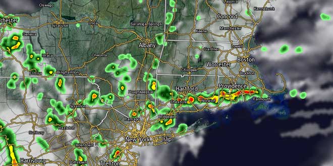
The very warm and muggy weather in Southern New England is hanging on into the second week of July. Monday marked the fifth straight day with a temperature above 90° at TF Green Airport. It is the longest heat wave in the Providence area in nearly five years. A series of weather disturbances moving along the United States and Canada border will lead to somewhat unsettled weather in the Northeast for the next few days. It will not be quite as warm, but the humidity will remain high, and the temperature will most likely not fall far below 70° in most of Southeastern New England through Thursday.
Scattered showers and thunderstorms are possible Monday evening. It will be partly cloudy after midnight, with lows between 68-74°. Showers and thunderstorms may be more widespread on Tuesday, especially across inland locations. The shower/storm threat exists from mid-morning through the afternoon. It will be humid, with highs in the upper 70s to low 80s. When it is not raining, the sky will be partly to mostly cloudy. In this pattern, it is a good idea to not cancel outdoor activities until the last minute, if possible. Showers and storms will be hit and miss.
Tuesday night will be muggy and mild. Another disturbance will approach the Northeast on Wednesday. Clouds will increase, with showers and thunderstorms possible from midday through the afternoon. Once again, the best chance of seeing rain is away from the coast. It will be breezy and humid, with highs in the upper 70s to mid 80s – warmest inland.
The best chance of widespread rain this week is Wednesday night through midday Thursday as a cold front slowly moves through New England. It will be mostly cloudy and muggy, with highs in the upper 70s to low 80s. It looks like the front will get just far enough offshore on Friday to allow for sunshine and lower humidity to arrive in Southern New England. Right now, the weekend forecast looks mainly dry and seasonably warm. The position of the front will be critical. If it stalls near or over SNE, then showers could be in the mix.
Tropical Storm Chantal heading for Caribbean islands
We’re keeping an eye on Tropical Storm Chantal as it heads for the Caribbean. As of 8 pm Monday, the storm had sustained winds of 50 mph. It was 320 miles east-southeast of Barbados and heading west-northwest at 26 mph. It is expected to become a strong tropical storm while moving to south of Puerto Rico by early Wednesday morning.
Computer model forecasts for Chantal
