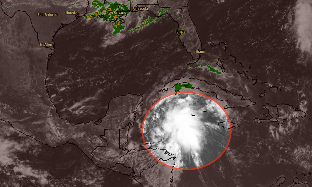
A disturbance in the northwestern Caribbean Sea between Jamaica and Central America is intensifying as it moves toward the Yucatan Peninsula. The National Hurricane Center has increased the odds of it becoming a tropical cyclone in the next 48 hours to 60 percent. It may become a tropical depression before reaching the Yucatan Peninsula on Thursday. Later this week the system will be in the Gulf of Mexico and may target the Gulf Coast of the United States by this weekend.
The National Hurricane Center is also monitoring a tropical wave in the Eastern Atlantic Ocean.
Computer model forecasts for Invest 92
TROPICAL WEATHER OUTLOOK
NWS NATIONAL HURRICANE CENTER MIAMI FL
200 PM EDT WED AUG 14 2013

FOR THE NORTH ATLANTIC...CARIBBEAN SEA AND THE GULF OF MEXICO...

1. THE BROAD AREA OF LOW PRESSURE IN THE NORTHWESTERN CARIBBEAN SEA IS
MOVING TOWARD THE WEST-NORTHWEST AT 10 TO 15 MPH. CLOUDINESS AND
SHOWERS ASSOCIATED WITH THIS LOW CONTINUE TO SHOW SIGNS OF
ORGANIZATION...AND A TROPICAL DEPRESSION COULD FORM BEFORE THE
DISTURBANCE REACHES THE YUCATAN PENINSULA ON THURSDAY. AFTER
THAT...THIS WEATHER SYSTEM IS FORECAST TO MOVE OVER THE GULF OF
MEXICO...WHERE UPPER-LEVEL WINDS WILL LIKELY BE A LITTLE LESS
FAVORABLE FOR DEVELOPMENT. THIS SYSTEM HAS A HIGH CHANCE...60
PERCENT...OF BECOMING A TROPICAL CYCLONE DURING THE NEXT 48
HOURS...AND A HIGH CHANCE...70 PERCENT...OF BECOMING A TROPICAL
CYCLONE DURING THE NEXT 5 DAYS. REGARDLESS OF WHETHER OR NOT A
TROPICAL CYCLONE FORMS...HEAVY RAINS AND GUSTY WINDS ARE FORECAST
TO SPREAD OVER THE YUCATAN PENINSULA AND BELIZE DURING THE NEXT DAY
OR TWO...AND INTERESTS IN THESE AREAS SHOULD MONITOR THE PROGRESS
OF THIS DISTURBANCE.
