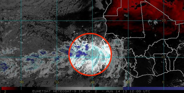
A strong tropical wave in the Eastern Atlantic Ocean has a high likelihood of becoming a tropical cyclone in the next 48 hours. The National Hurricane Center gives the disturbance a 70% chance of developing into a tropical cyclone in the next 48 hours, and a 80% chance of it becoming a tropical cyclone in the next five days. In the near term, conditions are favorable for intensification, but the environment will likely become a bit less favorable as the system moves west through the Atlantic Ocean later this week. The system is moving west at 10-15 mph. It is about 2,500 miles east of the eastern Caribbean islands.
The National Hurricane Center is also monitoring a disturbance in the western Caribbean Sea.
Computer model forecasts for Invest 93
TROPICAL WEATHER OUTLOOK
NWS NATIONAL HURRICANE CENTER MIAMI FL
200 PM EDT WED AUG 14 2013

FOR THE NORTH ATLANTIC...CARIBBEAN SEA AND THE GULF OF MEXICO...

CLOUDINESS AND SHOWERS ASSOCIATED WITH A LOW PRESSURE SYSTEM LOCATED
A COUPLE OF HUNDRED MILES SOUTHEAST OF THE CAPE VERDE ISLANDS
REMAIN WELL ORGANIZED...AND A TROPICAL DEPRESSION COULD FORM LATER
TODAY OR ON THURSDAY. THIS SYSTEM HAS A HIGH CHANCE...70
PERCENT...OF BECOMING A TROPICAL CYCLONE DURING THE NEXT 48 HOURS.
AFTER THAT...THE LOW WILL BE MOVING INTO A LESS FAVORABLE
ENVIRONMENT FOR DEVELOPMENT. THIS SYSTEM HAS A HIGH CHANCE...80
PERCENT...OF BECOMING A TROPICAL CYCLONE DURING THE NEXT 5 DAYS.
REGARDLESS OF ADDITIONAL DEVELOPMENT...THIS SYSTEM WILL LIKELY
BRING SHOWERS AND GUSTY WINDS TO THE SOUTHERN CAPE VERDE ISLANDS
LATER TODAY AND THURSDAY AS IT MOVES WESTWARD AT 10 TO 15 MPH.
INTERESTS IN THESE ISLANDS SHOULD MONITOR THE PROGRESS OF THIS
SYSTEM.
