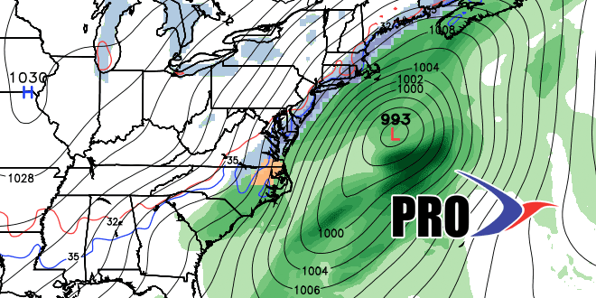
Half of the (ahem) fun of a four to five-day storm forecast is following the run to run computer model trends. That’s what we’re doing here. Seeing how the models are swinging back and forth and hopefully not flip-flopping on their solution for the middle of next week. I will list the different model names and include some pertinent graphics. Let’s take a look at what’s going on…
GFS Model
The GFS was out to sea with the storm a couple of days ago. Last night it trended very close to the Canadian and European. As of the 12Z (7AM EST) model run, it has shifted a bit farther east, but still brings a wintry mix to Southern New England. As we stated in the Long Range Forecast, this is not an ideal setup for a winter storm in Southern New England with no high pressure to the north to lock in the cold air. If this GFS track occurs, however, there should be enough cold air around to allow for snow accumulation – especially in the hilly part of western RI.
Canadian Model
The 12Z Friday run of the Canadian model is farther inland than earlier runs. Rather than tracking the storm over Southeastern New England like the 00Z run, the 12Z run takes it over New York City. The upshot is a wind-driven rain with temperatures approaching 60° for Southeastern New England if the storm takes the latest projected track. I think it’s a little overdone with the inland track, but I expect a track closer than what the 12Z GFS is showing.
ECMWF Model
The European model has been most consistent with delivering a storm that brings rain and snow to the Northeast. The track has wavered back and forth a bit, and that has major implications for the big cities on precipitation type. The 00Z Friday run of the Euro brought heavy snow to interior SNE and most of NH and ME. It also had accumulating snow in the rest of SNE as a second storm moved by Wednesday night. While the first snow in interior SNE makes perfect sense, we’re always a little leery of computer model forecasts that bring a lot of accumulating snow on the back side of these fast-moving storms or, in this case, a second wave of low pressure immediately in the wake of the first storm. Usually, when a storm gets north of Cape Cod, there is not a lot of wrap around moisture left.
GFS Ensemble
The Bottom-Line
We favor the track of the first storm that is much closer to the coast than the GFS is projecting. The start of the storm will most likely be rain for the I-95 corridor. The ECMWF has an interesting solution with a second storm right on the heels of the first. It’s a bit unusual, but could happen. The Japanese model hints at it, too. With a wet ground and a damp airmass starting in the upper 30s to low 40s, a change to accumulating snow could be difficult. It’s possible that it would change to snow Wednesday night, but not accumulate to the extent that the ECMWF is showing.
