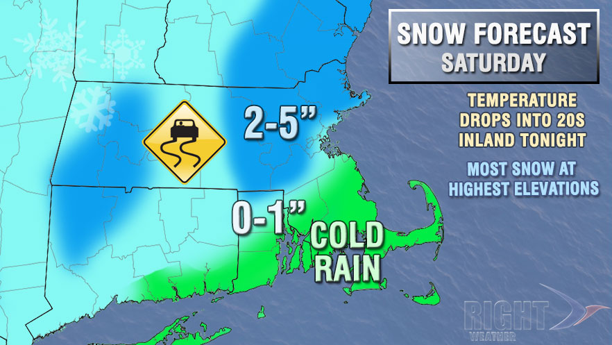
A vigorous developing storm system was bringing snow and rain to Southern New England on Saturday. The precipitation began as rain in most of RI and SE MA Saturday morning. Thunder rumbled with some of the rain as a testament to the energy associated with the developing storm. As colder air moved in, the precipitation changed from rain to snow inland, and it accumulated on untreated surfaces. The heaviest snow was moving into NE MA early in the afternoon. Occasional rain and snow is likely in Southeastern New England into Saturday evening. The temperature will stay above freezing, keeping roadways wet instead of icy through late in the day.

Colder weather will move in after precipitation ends, and some icy spots are possible Saturday night as the temperature drops into the 20s to low 30s. Sunday looks partly to mostly cloudy, brisk and chilly. Highs will be in the low to mid 30s. Passing flurries are possible, but no snow accumulation is expected.
Monday looks relatively quiet as an Arctic cold front approaches from the west. Highs will be in the mid to upper 30s with increasing clouds. Snow squalls and flurries are possible as the front moves late Monday afternoon or Monday evening.
Bitter cold weather is likely for the rest of the week. It looks dry for the most part, but we’ll have to watch for developing storms just offshore as Alberta Clippers move from Canada to the Great Lakes to the Atlantic Ocean. The first close call will be late Tuesday into Wednesday. Highs will only be in the 20s Tuesday-Friday, and low temperatures will be in the single digits and teens.


