Back in high school one of the popular cheerleader cheers during our soccer games was “Action, action, we want action – A-C-T-I-O-N!” Well, if it’s winter weather action you want, then there will be plenty of it in the next two weeks. It is highly unlikely that all the events will be all snow in Southern New England, and the odds strongly favor rain getting involved more often than not – at least in the upcoming week. It’s a trend we expected this winter when we gave the seasonal outlook, and after a mainly snowy January, it looks like we’re back into the mixed bag of winter weather for Southern New England.
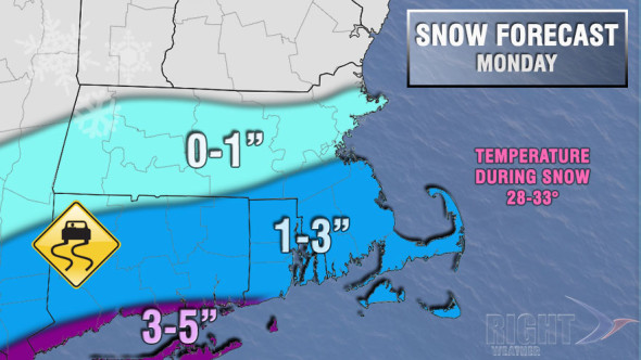
The first system, however, will likely be all snow on Monday. We have been eyeing (and expecting) a northward trend with the storm track in the past couple of days. Now, most computer models bring at least an inch of snow to the coast, with some bringing several inches to the coast, and a minor accumulation inland. The timing is during the day, and the temperature will be warmer than many recent events, so widespread accumulation on paved surfaces may not happen too easily. Look for 1-3″ of snow during the day on Monday – the best chance of 3″ is near the coast based on the current track. If the northward trend continues, then all of Southeastern New England could pick up a few inches.
There will be a break in the action on Tuesday before another storm system arrives Tuesday night into Wednesday. There will not be a ton of cold air around, and the current consensus track favors snow to mix to rain in Southeastern New England, with snow to a mix in interior Southern New England – from Worcester County to the Berkshires. The midweek storm will be moisture-laden, and several inches of snow are possible inland at the onset. There will be a fine line between moderate to heavy snow and sleet. That can wreak havoc on an accumulation forecast. The overall trend with the midweek storm is for it to track a bit farther south with redevelopment near the NJ coast. At this point, the redevelopment is not far enough south to lock in the cold air over Southeastern New England. If the trend continues, then the scenario gets snowier.
We are still expecting another storm next weekend, and more action after that through mid-February. This could be an epic pattern for part of the Northeast, but maybe not in Southeastern New England. At this point, it looks like Albany through Northern New England has the best chance of seeing the snow really pile up in the first two weeks of February.
Be aggressive, B-E aggressive, B-E A-G-G-R-E-S-S-I-V-E Aggressive! (That was the other cheer that the cheerleaders have left indelibly inked on my brain.) There is definitely an aggressive weather pattern setting up for the next few weeks.
