The Right Weather Spring Outlook turned out to be pretty accurate. The overall weather pattern has not changed too much in the last few months, and we were right about the spring gradually getting warmer (relative to normal) and May breaking the streak of six consecutive colder than normal months in Southeastern New England. We also called for near-normal precipitation, and TF Green Airport was only 8% above normal for the season. Now, as we head into June, it’s time to turn our attention to meteorological summer (June, July, August) and the Atlantic Hurricane season which runs from June 1 to November 30.
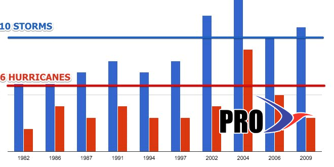
Last year’s hurricane outlook was a disaster for most forecasting outlets. It was an uneventful year after most forecasters predicted an above normal season. This year, assuming an El Niño continues to develop, the forecast could be easier. Typically, there is below normal activity in the Atlantic Basin during an El Niño. Of the last ten El Niños, there was only one year (2004) with above normal hurricane activity. As you can see in the video, we are not expecting this to be a particularly active year. However, that does not prevent Southern New England from being hit by a storm. The last hurricane to make landfall in Southern New England was Bob in 1991 – an El Niño year.
It does not look like the overall weather pattern will change much in the first half of June, and possibly longer. We are not expecting any extended searing heat for most or all of June. It’s possible the pattern could shift in July and/or August, but we do not expect as many 90° days as last year (13) in the Providence area this summer. Having said that, we think the average temperature will be slightly above normal.
Rainfall-wise, There will be several shots at steady rain in the first half of June, so the start of the summer may be wetter than normal. We expect the entire summer to feature near-normal rainfall. It’s always a tricky forecast because of the hit and miss nature of summer thunderstorms. See the video for more on our outlook.
