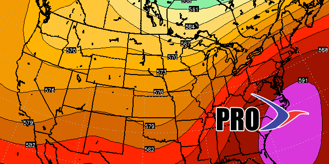
It’s hard to believe that meteorological summer is already more than half-finished. So far, there has been no extreme heat in Southeastern New England. Providence and Boston are still waiting on the first 90° day of the year. In fact, Providence has not been warmer than 88°. The last time it failed to reach 89° this far into the year in Providence was in 1932. The high temperature for that entire year was just 88°. There is a better than 50% chance that the temperature reaches 90° in the next couple of weeks. Climatologically, this is the warmest time of the year. The weather pattern looks relatively warm for the last two weeks of the month.
The first shot at 90° in on Sunday if clouds burn off to hazy sunshine with a southwest wind. The air aloft will be warm enough to support 90°, it’s just a matter of getting several hours of sunshine and keeping the wind from shifting to the south or southeast at TF Green. It will be quite humid on Sunday, and will likely feel like the 90s regardless of whether the temperature gets that high.
Showers and storms are possible on Monday as a cold front moves through. It will not be cooler behind the front, and there is another shot at 90° in the middle of next week.
Mid-summer is a good time to check in our summer forecast. So far, it is going pretty well. Here are the headlines published in early June.
It has certainly not been extremely hot. We thought it would be a bit muggier than it has been, but at least half the days so far this summer have featured above normal low temperatures – a sign that there is humidity in the air. There was above normal rain in June, and so far July is running near normal in Providence, and above normal near the coast. There has not been much tropical development so far, but we’re still favoring storms that form not too far from the Eastern Seaboard. The temperature was 1.6° below normal in June, and is slightly above normal in July.
There may not be too much rain in the last two weeks of July. There will be a few showers around on Saturday, but it will not be a washout. Then there is the Monday thunderstorm threat. After that, there will be a dry stretch that may last through next weekend. We’ll be watching for a disturbance early next weekend, but it may stay northwest of our area. If you have vacation in the next week or two, you can expect some decent beach weather with typical Dog Days conditions most of next week and, at least, part of the following week.
