

Tuesday featured record warmth in Providence with a high of 64° breaking the old record of 62° set in 1991. It hit 65° in Boston, tying the record high for the date. A cold front passes through tonight and brings in cooler, but not exactly cold (for February) weather on Wednesday. Expect dry skies through the day with lows in the upper 20s and highs in the low 40s.


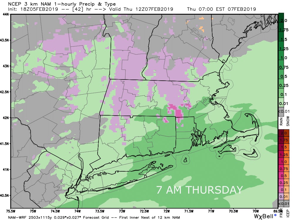
The weather gets interesting Wednesday night as a storm system passes by bringing freezing rain and rain to Connecticut, Rhode Island and Southeastern Massachusetts. The best bet for significant freezing rain that causes icy conditions is in the northwest and northeast hills of CT, and NW RI – north and west of I-295. Computer models are hinting at freezing rain in interior Southeastern Massachusetts, but I’m not sold on it yet. The graphic below shows where I think the freezing rain has the best chance of lasting for a few hours and causing enough glaze to make travel slippery. Outside of this area, there may be a brief period of freezing rain sometime between 11 p.m. – 3 a.m. but the temperature should be above freezing by 5 a.m., and I do not expect an icy commute in the I-95 corridor.


Any freezing rain inland changes to rain by 7-8 am Thursday, and rain continues elsewhere through the mid to late morning – ending first in western CT and last in eastern MA. Temperatures will likely be in the mid to upper 30s Thursday afternoon.

The next weather-maker arrives Thursday night into Friday. It will be warm enough for all rain, but it does not look heavy. Expect scattered showers with temps in the 40s to near 50. The rain threat ends late Friday afternoon. Colder air arrives for the weekend. Saturday and Sunday look dry with highs in the 30s – coldest on Saturday.
A weak system could bring a light snow accumulation Sunday night. Right now, it looks like an inch or less if it materializes. I’ll keep an eye on it. I’m confident in a strong storm system in the middle of next week. While there will likely be some snow, it does not look like an all-snow event for Southern New England. There’s a strong chance that mixed precipitation and rain get involved first at the coast and possibly spreading inland. The overall pattern looks more wintry in mid-February, so I do not expect that to be the only chance of snow between February 13-20.