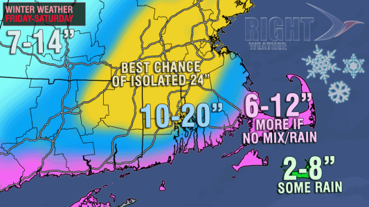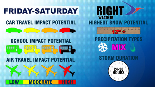
It is “go time” for a major Nor’easter in the Northeast Friday into Saturday. The latest computer model information has not backed off the potential for a major snowstorm with extremely strong winds in Southern New England. In fact, some of the computer model information received this morning suggests the Right Weather accumulation map may be on the conservative side!
This is likely not going to be a run of the mill Nor’easter. The exact track of the storm is still somewhat uncertain, but the focus is narrowing on a track that brings the heaviest snow within 50 miles of the I-95 corridor in RI and MA. It may be the biggest snowstorm to hit Southern New England since the January Blizzard of 2005. The National Weather Service has issued a Winter Storm Watch for most of Southern New England.
Timing
Snow or a mix of rain/snow will begin sometime Friday morning. It’s unclear if it will be around dawn or closer to noon. The precipitation will be steadier by mid to late afternoon, and there could be some rain mixed in with the snow from the coast to Providence through early in the evening. The height of the storm is likely to occur Friday night into Saturday morning. Wind-driven, heavy snow is likely in E CT, all of RI, and most of SE MA Friday night through dawn Saturday. The storm will continue to produce heavy, accumulating snow Saturday morning – with the focus shifting to Eastern MA. The storm will slowly move away from the coast Saturday afternoon, with the snow ending by mid to late in the afternoon.
Totals
It is likely that most of the area will receive at least a foot, with many approaching 20″ if the storm occurs as currently projected. The potential exists for 2 feet of snow in a fairly large part of Southeastern New England. It’s too early to say where the two foot amounts will occur as it will be dependent on where the heaviest snow bands set up Friday night. Unfortunately, that will not be known until the storm is approaching Southern New England Friday evening, but, it’s safe to say that this is a major storm for all of Southern New England. Impressive snow totals will stretch all the way back into Western MA and CT, and northward into, at least, the southern half of Northern New England. To put this storm in perspective, only three times since 1905 has Providence reached 20″ of snow from one storm. Today is the anniversary of The Big One – The Blizzard of 1978.

Other Impacts

The storm has the potential to bring hurricane force (73 mph) sustained winds to Eastern MA – particularly Cape Cod and the islands. Peak wind gusts could top 80 mph on the E MA coast from Boston to Nantucket. Peak gusts in RI may top 60 mph, with the highest gusts likely near the coast.
The combination of strong winds and heavy snow gives this storm a good shot at becoming a blizzard. The following criteria must be met for three consecutive hours to reach blizzard condition: sustained winds or frequent gusts to 35 mph and heavy snow with 1/4 mile or less visibility.
Coastal flooding is also a concern, especially in Eastern MA where astronomically high tides will occur Friday evening and Saturday morning. The Saturday morning high tide is higher, and with the storm forecast to slow down, moderate coastal flooding may occur.
Stay with rightweather.net for the latest on this storm. Download the FREE RightWX app and never miss an important update.


