The past three hurricane seasons have been hyperactive in the Atlantic Basin. 2010, 2011, 2012 all featured 19 named storms – tied for the third most on record. Of course, Southern New England has felt a significant impact from two of those storms – Irene in 2011 and Sandy in 2012. The combination of property damage and power outages has New Englanders feeling particularly hurricane-weary heading into the 2013 season.
A consensus among the experts
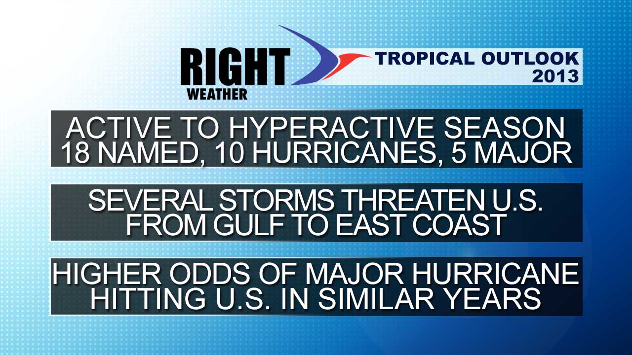
Unfortunately, the overwhelming consensus is that 2013 will be another active to hyperactive year for tropical activity in the Atlantic Basin – which includes the Gulf of Mexico, Caribbean and Atlantic Ocean. Below is a table of hurricane season forecasts from leading experts.
| Organization | Named Storms | Hurricanes | Major |
| NOAA | 13-20 | 7-11 | 3-6 |
| Colorado State | 18 | 9 | 4 |
| Weatherbell | 16 | 12 | 5 |
| NC State | 13-17 | 7-10 | 3-6 |
| TropicalStormRisk.com | 15 | 7.5 | 3.4 |
| Accuweather | 16 | 8 | 4 |
| Penn State | 16 (12-20) | ||
| Institute of Meteorology, Cuba | 17 | 9 | |
| UK Met Office | 14 (10-18) | 9 | |
| 30 year average | 12.1 | 6.4 | 2.7 |
Forecast factors
As you can see, there is not a single forecast that predicts an average or below average hurricane season. Let’s take a look at some of the factors that are contributing to the active hurricane season forecast. There are long-term (15-30 year) patterns that are shown to have a direct impact on the amount of hurricane activity in the Atlantic Basin. Currently, the Atlantic Basin is in an active phase that began around 1995 and may continue for another decade or so. Even though these ocean/weather patterns have an influence on the hurricane activity for decades at a time, there can be factors, like El Niño, that can limit hurricane in any given season.
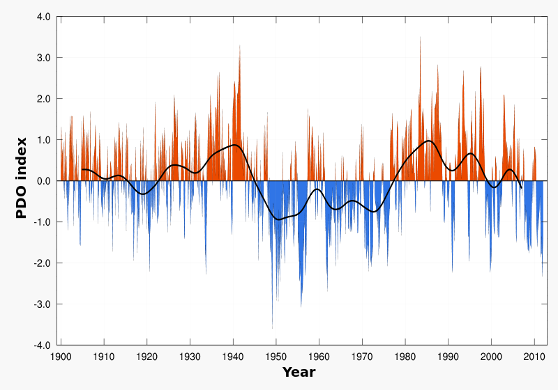
This season there is not expected to be an El Niño that could limit the activity in the Gulf of Mexico and Atlantic Ocean. Neutral ENSO conditions are expected to continue until, at least, the early fall. The Atlantic Multidecadal Oscillation, which is most easily seen in the sea surface temperatures, is expected to remain positive – or warmer than normal. Tropical systems thrive in warmer waters. Conversely, the Pacific Decadal Oscillation is in a cold phase that has been fairly consistent for the past five years or so. The combination warm AMO and cold PDO, with no El Niño to limit development, should lead to another very active hurricane season in the Atlantic Basin. There are other factors that may play into this hurricane season, such as the amount of Saharan dust that forms in Africa. Right now, that does not look like a factor, but it can change during the summer.

The Right Weather forecast
With all of this in mind, the Right Weather forecast is for a very active hurricane season in the Atlantic Basin. The bigger question is “will one of those storms impact New England?”. Unfortunately, it is impossible to know if that will happen. There is, however, a tendency for storms in this pattern to track closer to the East Coast of the United States. We have certainly seen that over the past couple of years, and we expect that there will be some threats again this year. The problem is there is a very small difference between a direct hit and a storm that narrowly misses with little to no impact in New England.
The season may also get off to an early start with the remnants of Pacific Hurricane Barbara crossing Mexico and reforming as Tropical Storm Andrea in the Gulf of Mexico in the first week of June.
No major hurricanes since 2005 in U.S. – are we due?
A major hurricane has not made landfall in the United States since Wilma in 2005. The historical average is 52% and some forecasters are saying that “we’re due” for a major hurricane to hit the United States. Remember the atmosphere behaves much like a slot machine and one does not get “due” for certain types of weather. This could be the third straight year that a hurricane or tropical storm impacts the Northeast – by the logic of being “due” for a storm, it could be argued that we should be in the clear because there have been storms the past two years. A better way to say it would be that this year’s pattern favors a major hurricane strike for the United States. When looking at past years with similar AMO, PDO and ENSO conditions, the odds of hurricanes striking the U.S. are higher than normal.
A look at the accuracy of hurricane season forecasts
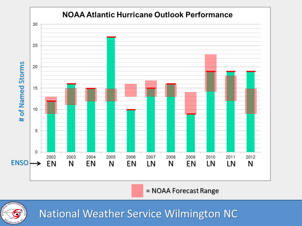
So, how accurate are seasonal forecasts? Not as accurate as we would like. Below is a look at the NOAA seasonal forecast range (pink) vs. the number of observed named storms each year since 2002. The actual number of storms has fallen within the range given by NOAA in 6 of the past 11 years. That is not a great average, but, in our opinion, there were really only three blow forecasts 2005, 2006, and 2012. ’05 was historically hyperactive, ’06 was a lot less active than the NOAA prediction, and last year feature four more storms than the high end of the NOAA forecast.