A moderate snow event is in the forecast for most of Southern New England this weekend. While the storm is not going to bring huge snowfall totals, it will most likely deliver enough snow to be plowed and shoveled in most spots by Sunday morning. Light snow will develop on Saturday, and it may stick immediately with temperatures in teens and 20s. The height of the storm is Saturday night, and that is also the time when mixed precipitation or rain may get involved near the coast to the I-95 corridor. Right now, we are leaning toward the bulk of the precipitation being snow for Providence and Boston. Steady precipitation will taper to showers and flurries in Southern New England Sunday morning.

Car Travel
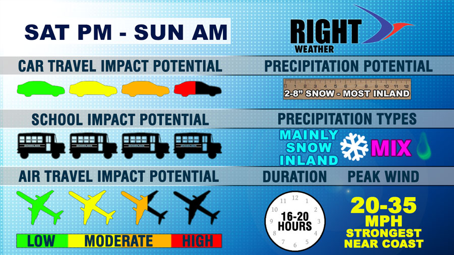
Slick roads are possible as soon as Saturday afternoon if the snow arrives just a bit ahead of schedule. It will be snowy Saturday evening and overnight. Cold air will stay entrenched in interior SNE.
Air Travel
Flights in the Mid-Atlantic may be affected on Saturday. The height of the storm is Saturday night, so there should not be major problems at Logan or TF Green Saturday afternoon or Sunday morning.
Precipitation Type and Totals
Mainly snow inland, snow to a mix and/or rain near the coast. It could be as little as 2″ of snow before a change to mix or rain near the coast. The potential exists for more than 6″ in many spots away from the coast. We issued a first look accumulation map for Right Weather Pro subscribers this morning.
Winds
The wind does not look like a huge factor, but there could be some 30+ mph gusts near the coast late Saturday evening through early Sunday morning.


