The active winter weather pattern will continue with another storm on Wednesday. Snow will arrive before dawn, and it will quickly become moderate to heavy. There is the possibility of the snow changing to a wintry mix before noon, especially south of I-95. However, the storm is likely to have a significant impact on many aspects of everyday life in Southeastern New England.
Check out the full forecast here: http://goo.gl/rtX8rp

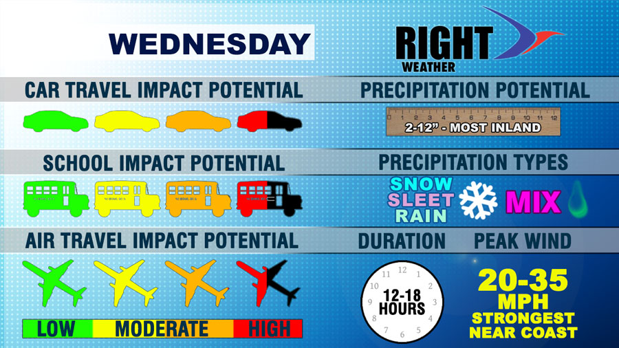
Car Travel Impact – The Wednesday morning commute could be nightmarish, especially north of Providence. Moderate to heavy snow is likely between 7 am – 9 am. There may be a change to mixed precipitation by midday, and that would help road crews get a handle on the situation before the evening commute. A change back to snow is likely late in the day, but it will be much lighter than the precipitation in the morning.
School Impact – There is a good chance Wednesday is another snow day away from the coast. It’s a tougher call near the coast because the precipitation will likely change from snow to a mix during the morning. However, it will most likely still be snow during the normal start of school. We expect delays or cancellations near the coast, and cancellations inland where snow will last through most or all the morning.
Air Travel Impact – Flying into or out of Northeast airports could be challenging on Wednesday. Logan, in particular, will be hard hit Wednesday morning. Moderate to heavy snow is likely all morning. The precipitation may change to sleet or freezing rain at TF Green by mid to late morning. Delays are possible.
About those snow totals….This is a case where the final Southern New England snow totals could be in an even bigger range than we have shown on the graphic. It’s possible Nantucket will get nada, and part of interior MA picks up 15″ of heavy snow. The range indicated is for RI, SE MA, and E CT. The higher totals will be inland, the lower totals near the coast.
Wind impact – The wind will be gusty near the coast, but it does not look like it will be strong enough to cause damage.
Duration – The storm will linger into Wednesday evening. The heaviest precipitation will happen in the first 1/3 of the storm. Slick roads are possible Wednesday night as the temperature falls into the low to mid 20s late at night.


