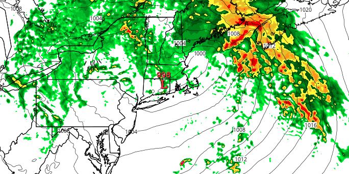
A potent storm system will bring a period of heavy rain to Southeastern New England late Saturday night and Sunday morning. It will be windy, and thunderstorms are possible. There is a slight chance of severe weather in any of the thunderstorms. The worst weather will likely happen between 4am-10am, with 1-2 hours of heavy rain expected in that period. Most spots will receive 1-2″ of rain from the storm.


Even though the worst weather will likely end by 9-10 am, there is still a shower threat into the afternoon. It will be mostly cloudy and muggy, with highs in the upper 60s to low 70s. Overall, not a great end to the weekend. Skies will become partly cloudy Sunday night. Lows will be near 60 with less humid weather arriving.
MONDAY
A weak disturbance will spin through New England on Monday. It will be partly cloudy in the afternoon. There is a slight chance of a pop-up shower or thunderstorm. Highs will be in the mid to upper 70s. It will not be a muggy day. Look for a 10-20 mph west-southwest breeze.
MIDWEEK
Tuesday should be a decent day. Highs will be in the upper 70s to low 80s with mostly sunny skies. A front moving through on Wednesday will bring scattered showers/storms on Wednesday. It will be seasonable, with highs in the upper 70s to low 80s. Thursday looks like a dry day, with highs in the 70s at the beach, and low 80s inland.


