Summer 2012 Recap

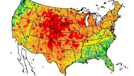
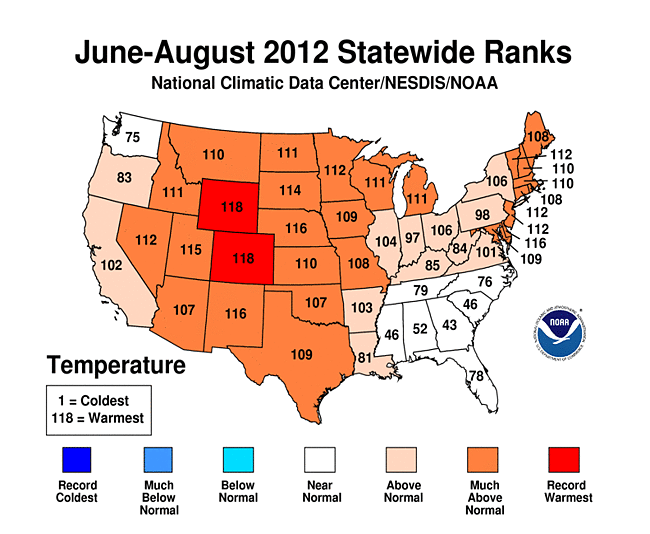
The summer (June-August) of 2012 was the third warmest on record in the United States. Two states, Colorado and Wyoming, experienced their hottest summer in the past 118 years. Nearly 20 other states were in the top-10 warmest on record. The New England states were all between the seventh and eleventh warmest on record.
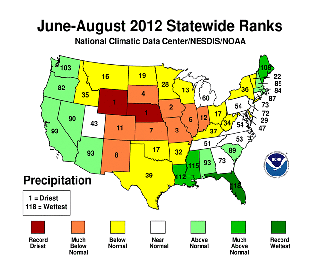
Not only did Wyoming experience the warmest summer on record, it was also the driest summer in the Equality State. Nebraska also had their driest summer in the past 118 years. Eight states were in the top-10 driest. In the Northeast, after a drought in the spring, most states saw at least the normal amount of rain, with Maine experiencing the eleventh wettest summer in the past 118 years.
After a relatively cool June, the rest of the summer was warmer than normal in Southern New England. July was in the top-10 warmest in Providence, Worcester and Hartford. August was in the top-10 warmest in Boston, Worcester, and Hartford. It was the fifth warmest summer overall in Hartford. Providence was 0.5 degree warmer than normal – by far the coolest season of the dating back to last summer.
While the Midwest and Rockies were experiencing weeks of extreme heat, there was not a lot of it in Southern New England. In fact, there was not a single record high temperature set in Providence. Plus, only five record highs were tied or broken in at the four major climatological sites in Southern New England. Three of those record highs were established on June 21.
From the National Weather Service Boston office in Taunton, MA
...SUMMER IN REVIEW...

ALL DATA PRESENTED HEREIN IS PRELIMINARY AND SUBJECT TO REVISION.

                             BOSTON

            ...PERIOD OF RECORD: 1872 TO PRESENT...

       AVG HIGH  AVG LOW  AVG MEAN  PCPN  SNOW  REMARKS
       --------  -------  --------  ----  ----  -------

JUN:      73.8     59.7     66.8    4.71
          -2.1     +0.2     -0.9   +1.03
JUL:      83.5     67.2     75.4    3.88
          +2.1     +1.8     +2.0   +0.45

AUG:      82.1     67.2     74.7    3.08        4TH WARMEST
          +2.5     +2.6     +2.6   -0.27

SEASONAL SUMMARY
----------------

SUMMER:   79.8     64.7     72.3   11.67
          +0.8     +1.5     +1.2   +1.21

RECORDS
-------

06/21...RECORD HIGH...96...PREVIOUSLY 95 IN 1949
06/21...RECORD HIGH MINIMUM...80...PREVIOUSLY 74 IN 1942
JUNE...MONTHLY RECORD HIGH MINIMUM...80...TIED WITH JUNE 6 1925

ADDITIONAL NOTES
----------------

SUMMER 2011:      72.8 (+1.7) 7TH WARMEST AVG
AUTUMN 2011:      58.4 (+3.9) ALL-TIME WARMEST AVG
WINTER 2011-2012: 37.2 (+5.4) 2ND WARMEST AVG
SPRING 2012:      53.4 (+5.3) ALL-TIME WARMEST AVG

_________________________________________________________________

                            HARTFORD

            ...PERIOD OF RECORD: 1905 TO PRESENT...

       AVG HIGH  AVG LOW  AVG MEAN  PCPN  SNOW  REMARKS
       --------  -------  --------  ----  ----  -------

JUN:      79.3     57.6     68.5    4.22
          -0.3     +0.3      0.0   -0.13

JUL:      87.1     65.3     76.2    4.34        4TH WARMEST AVG
          +2.6     +2.6     +2.6   +0.16

AUG:      85.7     62.5     74.1    4.12        8TH WARMEST AVG
          +3.0     +1.4     +2.2   +0.19

SEASONAL SUMMARY
----------------

SUMMER:   84.0     61.8     72.9   12.68        5TH WARMEST AVG
          +1.7     +1.4     +1.5   +0.22

RECORDS
-------

06/20...RECORD HIGH...97...PREVIOUSLY 96 IN 1995
06/21...TIED RECORD HIGH...96...ALSO SET IN 1953
06/21...TIED RECORD HIGH MINIMUM...73...ALSO SET IN 1923

07/18...RECORD HIGH...100...PREVIOUSLY 99 IN 1982

08/15...RECORD DAILY PRECIPITATION...1.33...PREVIOUSLY 1.18 IN 2004

ADDITIONAL NOTES
----------------

AUTUMN 2011:      55.8 (+3.0) 4TH WARMEST AVG
WINTER 2011-2012: 35.0 (+5.9) 2ND WARMEST AVG
SPRING 2012:      54.3 (+5.4) ALL-TIME WARMEST AVG (TIED WITH 2010)

_________________________________________________________________

                           PROVIDENCE

            ...PERIOD OF RECORD: 1905 TO PRESENT...

       AVG HIGH  AVG LOW  AVG MEAN  PCPN  SNOW  REMARKS
       --------  -------  --------  ----  ----  -------

JUN:      75.4     57.6     66.5    5.02
          -2.1     -0.8     -1.5   +1.38

JUL:      84.8     65.8     75.3    2.74        10TH WARMEST
          +2.0     +1.6     +1.8   -0.55

AUG:      82.7     64.7     73.7    3.97
          +1.3     +1.5     +1.4   +0.37

SEASONAL SUMMARY
----------------

SUMMER:   81.0     62.7     71.8   11.73
          +0.4     +0.7     +0.5   +1.20

RECORDS
-------

06/21...RECORD HIGH MINIMUM...75...PREVIOUSLY 73 IN 1923 AND 194
06/25...RECORD DAILY PRECIPITATION...1.34...PREVIOUSLY 1.14 IN 2006

ADDITIONAL NOTES
----------------

SUMMER 2011:      72.2 (+0.9) 10TH WARMEST AVG
AUTUMN 2011:      57.1 (+2.8) 3RD WARMEST AVG
WINTER 2011-2012: 36.5 (+4.7) 2ND WARMEST AVG
SPRING 2012:      53.1 (+4.3) 3RD WARMEST AVG

_________________________________________________________________

                           WORCESTER

            ...PERIOD OF RECORD: 1892 TO PRESENT...

       AVG HIGH  AVG LOW  AVG MEAN  PCPN  SNOW  REMARKS
       --------  -------  --------  ----  ----  -------

JUN:      73.5     56.3     64.9    5.53
          -0.6     +0.3     -0.1   +1.34

JUL:      82.4     64.1     73.3    3.16        7TH WARMEST AVG
          +3.5     +2.6     +3.1   -1.07

AUG:      80.2     63.6     71.9    6.70        8TH WARMEST AVG
          +2.9     +3.2     +3.1   +2.99        10TH WETTEST

SEASONAL SUMMARY
----------------

SUMMER:   78.7     61.3     70.0   15.39
          +1.9     +2.0     +2.0   +3.26

RECORDS
-------

06/21...TIED RECORD HIGH...91...ALSO SET IN 1953
06/21...TIED RECORD HIGH MINIMUM...74...ALSO SET IN 1923

ADDITIONAL NOTES
----------------

AUTUMN 2011:      54.5 (+4.0) 3RD WARMEST AVG
WINTER 2011-2012: 32.8 (+6.0) 2ND WARMEST AVG
SPRING 2012:      51.3 (+5.6) ALL-TIME WARMEST AVG


