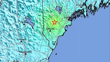
A 4.0 magnitude earthquake struck in southern Maine at 7:12 pm on Tuesday, October 16. It occurred about 3 miles west of Hollis Center, ME, which is 15 miles west of Portland, ME. The quake was 4.2 miles beneath the Earth’s surface.
The quake was felt in all of New England and Eastern New York.

Click here for more information on the earthquake.
http://earthquake.usgs.gov/earthquakes/eventpage/usb000d75b#summary
More information on earthquakes in New England
https://www2.bc.edu/~kafka/Why_Quakes/why_quakes.html
A 4.0 magnitude earthquake is considered light, with an estimated 10,000-15,000 earthquakes pre year between 4.0-4.9 magnitude. It is described by the USGS as “Felt indoors by many, outdoors by few during the day. At night, some awakened. Dishes, windows, doors disturbed; walls make cracking sound. Sensation like heavy truck striking building. Standing motor cars rocked noticeably.”

Our earthquake reports have a DYFI? tab. That's "Did You Feel It?" Here's the direct link: http://t.co/WuNNxqsg
— USGS (@USGS) October 16, 2012
4.5 magnitude earthquake felt in Seabrook. Reports of peoples pictures falling off their walls
— Ricky Firey 🌬️💙 (@GraniteState_WX) October 16, 2012
via Maine Geological Survery, interval time between 4.6M #earthquake is around 24 years. http://t.co/UvIOIBOu
— Tim Pandajis (@TimPandajisKHOU) October 16, 2012


