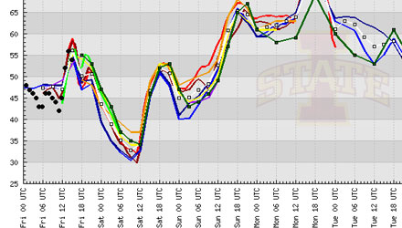
The cold air that will ride into Southern New England on a northwesterly breeze will not be sticking around for very long. In fact, it’s about a quick an airmass change as you’ll ever see. The temperature is going to go from near 60 to near 30 to near 70 in the span of about 55 hours.
The chilly air charges in tonight, and some places in NW RI may see the mercury dip below 30 degrees by dawn Saturday. High pressure quickly moves overhead midday Saturday, and then offshore by early Sunday. At the same time, a storm system rapidly moving out of the Midwest into the Great Lakes will drive the wind around to the southwest. Some of the areas that dip into the upper 20s Friday night in Southern New England may see the temperature bounce back to 70 degrees by Sunday afternoon.
The tricky part is trying to project how much sunshine we’ll get on Sunday afternoon. There is a much better chance of breaking into it in Connecticut and Western Massachusetts than in Rhode Island or Southeastern MA. In any event, even RI and SE MA should be well into the 60s by 3 pm Sunday. The leading edge of the warmer air will likely be accompanied by some showers Sunday morning. A southwesterly wind will increase to 10-20 mph once the warm front passes. Warm fronts can be very slow to move through during October, so, I wouldn’t be surprised if RI and SE MA didn’t break into sunshine on Sunday afternoon.
The areas away from the coast that don’t see 70 degrees on Sunday will likely get there on Monday. Near the coast, because of the southwesterly breeze, the high temperatures may stay in the mid to upper 60s on Monday, too.

Hello First Snow! pic.twitter.com/Q8cSWwPP
— OkemoMountain (@OkemoMountain) October 12, 2012


