Sandy is a large and dangerous storm with the potential for significant damage in the Northeast from hurricane force winds, coastal flooding due to storm surge and huge waves, and heavy rain that will lead to river flooding west of the center of the storm. As of 8AM Saturday, Sandy was a minimal hurricane with winds of 75 mph. The National Hurricane Center briefly weakened Sandy to a tropical storm early Saturday morning. Sandy is forecast by all computer models to restrengthen slightly and have a major impact from the Mid-Atlantic to New England, and some of the strongest winds will occur in Southern New England.
Most computer model projections bring Sandy into the coast between Delaware Bay and New York City, with many focused on the Atlantic City area. Because the storm will be so large and likely not rapidly weakening, major impacts will be felt hundreds of miles from the center of the storm. Sandy will be over very warm water (The Gulf Stream) through tomorrow night. It will also begin to interact with a jet stream that will help it to strengthen or maintain intensity right before landfall. Typically, the jet stream has a negative effect on tropical systems, but with Sandy becoming post-tropical, the effect of the jet stream will be similar to when a Nor’easter is energized.
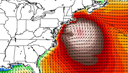
Hurricane Sandy Forecast For Southern New England
Saturday
Saturday will be a decent day to prepare for the storm. It will be partly sunny, with highs in the low to mid 60s, and not too much of a breeze.
Sunday
The wind will pick up on Sunday, especially in the afternoon. The wind should be 20-35 mph by late in the day. It will be mostly cloudy, with the chance of a few showers, and highs in the mid to upper 50s. The wind will be out of the north-northeast.
Sunday Night
The weather conditions will continue to deteriorate Sunday night. The wind will stay in the 20-30 mph range inland, but by dawn Monday, the wind near the coast should be 30-50 mph. The wind direction will be out of the northeast. It will be cloudy to mostly cloudy with scattered showers. The temperature will be in the low 50s.
Put your cellphone on the charger! Widespread power outages aren’t likely by Monday morning, but it’s better to be safe than sorry.
Monday
The brunt of the storm will hit Monday into Monday night. Those near the coast will wake up to a howling wind on Monday, and it will spread inland and get worse during the day. By midday, sustained winds of 25-40 mph are likely inland, with 40-55 mph sustained winds near the coast. Gusts of 10-20 mph above sustained winds are possible.
The worst of the wind from Sandy will likely occur from 2pm Monday until 2am Tuesday. If current computer model projections are correct, Sandy will bring 35-65 mph winds to inland locations, and 55-80 mph winds to the coast. The wind direction will shift from the northeast to east Monday evening. This is when most of the wind damage will occur from Hurricane Sandy. There will also likely be some heavy showers Monday afternoon and/or evening. The temperature will rise into the low to mid 60s, but that doesn’t matter too much, right?
After the burst of strongest winds, we’ll likely see them subside by late Monday night to 25-50 mph, with the strongest gusts near the coast.
Tuesday
Once the storm moves inland, it will gradually weaken. Tuesday looks breezy to windy, and cooler. There is stil the chance of some showers.
Halloween Outlook
We’ll still have some influence from the storm on Halloween. It will be breezy during the day with some showers moving through. With any luck, the wind will diminish and the rain will stop in time for trick or treating – provided the city/town you live in hasn’t cancelled it!
Wind-related #sandy preps: Furniture, kids toys, trash cans, etc in. Secure or disassemble trampoline. Carefully trim branches around house.
— Right Weather (@RightWeather) October 27, 2012
- Follow all the updates on the Fred Feed Live Blog
- Download the FREE RightWX app for your Android or iOS device to stay informed if you lose power
- Interactive Hurricane Tracker
- Hurricane preparation tips
- Sandy impacts
- Protecting your pets during a major storm


