Hurricane Sandy continues to pose a major threat to the Megalopolis from Washington D.C. To Boston and beyond. There are nearly 70,000,000 people that will be impacted by this storm when it makes landfall early next week. The latest computer model tracks through early Friday evening continued to put the landfall somewhere between the Delaware Bay and Long Island, NY. Because of Sandy’s size and unique meteorological features, hurricane conditions may be spread out over a large geographical region – especially to the north of the storm’s center.
It cannot be stressed enough that Sandy’s track as a category one hurricane approaching from the southeast to northwest and hitting the New Jersey coast will have major impacts in Southern New England. Here is a region by region breakdown of the storm’s impacts based on that very scenario. This is a preliminary projection, and will likely be updated several times before the storm’s arrival.
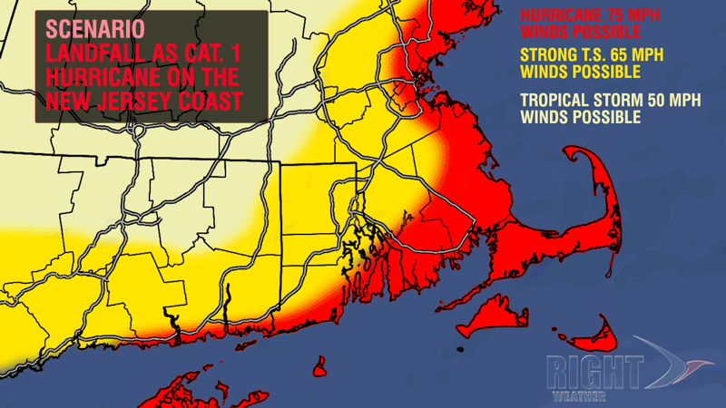
Sandy Impacts – Southern Rhode Island, Interior Southeastern Massachusetts, and Coastal Connecticut
Includes Providence, Westerly, Newport, Warwick, Fall River, Groton and surrounding communities
These areas are in for a very rough ride if Sandy makes landfall on the New Jersey coast as a Cat. 1. The areas closest to the coast have the likelihood of seeing sustained winds of 50-60 mph, with some 75 mph gusts possible. A bit farther inland, into the Providence area, sustained winds of 45-55 mph are likely, with some 65-70 mph gusts possible. These winds are stronger than what was experienced during Tropical Storm Irene last year, so there would likely be widespread power outages.
Storm surge, coastal flooding, and beach erosion are also major concerns for these areas. A 4-6 ft. storm surge is possible at multiple high tide cycles. Get the tide forecasts at rightweather.net. The beaches will be battered by enormous waves of 8-16 ft., and offshore seas will be 15-30 ft. It is one of the most ideal setups for a significant coastal flooding, and beach erosion event in recent memory. Because of the astronomical high tides and the relatively slow movement of the storm, the coastal impacts will likely be worse than during Irene. Because of the strong easterly winds for a while before the storm even arrives, there is higher than normal potential for coastal flooding in Long Island Sound.
This part of Southern New England may experience some heavy showers, but significant river and stream flooding is not a major threat with a storm track into the Jersey Shore. 1-3″ of rain may fall, with the heavier totals likely the farther west you go.
Sandy Impacts – Eastern Massachusetts, Cape Cod and Islands
Includes Boston, Plymouth, New Bedford and surrounding communities
After evaluating the data and reading some great technical discussions by well-respected meteorologists, it appears that some of the strongest wind from Sandy may be felt in these regions. A conservative estimate is for sustained 50-60 mph winds, with hurricane force (74 mph+) wind gusts if Sandy makes landfall on the Jersey Shore as a Cat. 1. On the high end, these areas could see sustained 70+ mph winds, with gusts over 90 mph. Widespread downed trees and power lines are likely in both scenarios, with the high end scenario being one of the biggest storms to hit Eastern MA in decades.
Coastal flooding is also a major concern in these areas. The initial projections are for a 4-6 foot storm surge which may occur at multiple high tide cycles. The tides are astronomically high early next week. Get the tide forecasts at rightweather.net. In addition to the storm surge, there will be 10-20 ft. waves crashing onshore, and 20-40 ft. seas offshore. The constant battering of the shore by the huge breakers is sure to cause extensive beach erosion especially on east and south facing coastlines.

There will likely not be a lot of heavy rain in these areas because they will be so far removed from the center of the storm.
Sandy Impacts Northern Rhode Island, Interior Connecticut, and Massachusetts west of I-495
Includes Woonsocket, Willimantic, Worcester, Wrentham, Hartford, Springfield
These communities, while likely outside of the worst that Sandy has to offer, will still get walloped by some nasty weather. The winds should not be quite as strong as near the coast. 40-50 mph sustained winds, with gusts to 60 mph are possible with a storm track making landfall on the New Jersey coast. Those winds are strong enough to down trees, branches, and power lines, leading to, at least, scattered power outages. These areas would experience more wind if the storm track shifted to Long Island instead of the New Jersey shore.
Some heavy rain is likely in these communities. A general 2-5″ of rain is possible, with the higher totals as you head west into Western CT and Western MA.
Hurricane Sandy timeline
The weather is expected to deteriorate Sunday with some showers and increasing winds. The storm will be long-lived, and strong winds are likely all day Monday, and they will peak Monday night. The storm will slowly weaken once it moves inland, so the wind will continue to howl through Tuesday night, and depending on the storm’s ultimate track after landfall, breezy, showery conditions could persist on Halloween. It is a long-duration event, and, if we get hit hard, cleanup and power restoration could be hampered by the bad weather conditions into the middle of next week.
Download the FREE RightWX app for your Android or iOS device prior to the storm.


