Hurricane Sandy continues to move through the Bahamas, and, as of 10 pm Thursday it was looking a little ragged on satellite imagery as it began to interact with a trough that will temporarily draw it to the northwest before a turn to the northeast on Saturday. Sandy will head northeast until late Sunday before turning to the north and then northwest on Monday evening. Confidence is growing in a storm track that brings Sandy into the Mid-Atlantic states between late Monday night and Tuesday afternoon.

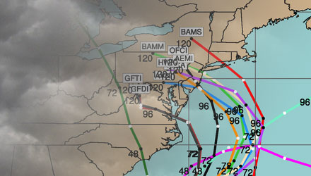
On Wednesday evening, storm tracks ranging from Maryland to Newfoundland seemed reasonable. By Thursday evening, that focus had narrowed considerably. The National Hurricane Center “cone of uncertainty” stretches from about Cape Hatteras, NC to Boston, MA. The middle of that cone is in New Jersey, and I can’t disagree at all with that track.
No specifics yet for Southern New England
As much as I would like to, it is still too early to talk about specifics regarding the timing and intensity of the storm. For a storm that is still three days away, it has a high probability of bringing at least 40 mph winds to all of Southern New England. We don’t know yet how high the winds will get. It’s still possible Southern New England could see 70+ mph winds – especially near the coast.
The storm is not going to be a very fast mover, so the storm surge and coastal flooding could be some of the worst this area has seen in decades. A track to our south brings in persistent east (first NE, then SE) wind, and the highest seas are also on the northern side of a hurricane approaching from the SE to NW due to the counter-clockwise circulation of the storm. High tides in Rhode Island are in the mid-morning and mid-evening Monday through Wednesday. It’s likely that multiple high tide cycles will cause coastal flooding. Oh yeah, it’s also an astronomically high tide because of the full moon.
With a projected track to our south, the threat of flooding rain is lowered. There will be some heavy rain bands that come through, but, a lot like Irene, they will not be heavy or long-lived enough to cause flooding problems.
Daily Forecast Summary
The weather will be relatively quiet for the next couple of days. We’ll see partly cloudy skies with highs Friday and Saturday in the 60s – nice weather to take care of some basic outdoor storm preparations. Some showers may arrive on Sunday as Sandy begins to interact with the disturbance over the Ohio Valley that will draw it close to the coast. It does not look like a washout, but I would not put off many outdoor preparations to Sunday – just in case.
The weather will likely deteriorate Sunday night with windy showers, and the brunt of the storm should occur Monday into Tuesday.
Looking ahead to Halloween, Sandy will still be hanging around in the Northeast. The storm will be weakening, but blustery and cool conditions are likely for trick or treating. There may still be some lingering showers.
Cool, brisk weather my stay right through the end of the work week.
Final Thoughts
Hurricane Sandy still has the potential to be a historically bad storm for the Mid-Atlantic and Northeast. It is already a large storm, and should get bigger before reaching the United States. Tens of millions of people will be affected by this storm. The key things I’ll be looking at on Friday are the updated computer model tracks, and Sandy’s central pressure and satellite imagery as it moves away from the Bahamas. I think we’ll have a better idea of whether Sandy will be something extraordinary or just a major hassle by Friday evening or Saturday morning. In the meantime, there are a few pages on rightweather.net that you may want to check out.
Fred Feed Live Blog – updates throughout the day, and your questions answered


