Is Hurricane Sandy being overhyped?

As someone who has written over 8,000 words on a storm that is still 1,600 miles from the coast of Rhode Island, I may not be the best qualified person to answer the question “Is Sandy being overhyped?”. I can honestly say I haven’t watched one minute of television coverage regarding Sandy. I left the TV business, remember? I am among those who consume most of their media online. So, this analysis will come from the online perspective only – specifically what I’m seeing on Facebook and Twitter. First, a little background on the overall setup and why in some circles it is all Sandy, all the time.
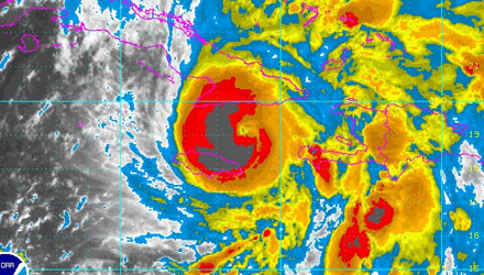
Sandy is getting a lot of attention, and deservedly so. At the risk of sounding too cliché, Sandy may end up being the sequel to The Perfect Storm. I don’t think it’s a coincidence, either, that both storms struck near Halloween. The same is true for the freak October Nor’easter that brought heavy snow to Western New England. In fact, right now, I think the brunt of Sandy will be on Monday, October 29 – the exact date that the Nor’easter hit last year. Mid to late October is a time of transition, and potentially volatile weather, in the Eastern United States. The ocean is still relatively warm, which is particularly true this year, there can still be tropical systems (Hi, Sandy), and there are also intrusions of unseasonably cold air from time to time – remember the snow plows last year. So, there is a precedent, in recent memory, for some absolutely wild weather to occur in Southern New England in late-October.
With that precedent already established, many computer models are spitting out stats for Sandy similar to 73 homeruns in one season and 7 Tour de France titles. I’m not saying there are PED’s involved, but the numbers (pressure, wind, waves) being projected for Sandy by some normally reliable computer models are enough to make a normally cautious meteorologist very weary, and some weather weenies giddy with excitement and hoping (why I don’t know) that the storm meets or exceeds those lofty projections.
You may not be aware of it, but there is new weather information constantly coming in. It really is nearly 24/7/365. I had a dentist appointment and a haircut today – both strategically placed around big computer model runs, and I still felt like I was missing the latest on the storm. If you follow a group of meteorologists on Twitter, you will get a constant feed of new recon data, computer model information including storm track, intensity, wave height, wind speed, rain totals and much more. In 2012, it’s also easy to quickly look back and compare analog storms or similar past weather setups for even more perspective on what could happen. There is a category 5 hurricane of information being released on this storm.
The question still remains, though, is it being overhyped? Heck, I’ve already been accused of downplaying it because two days ago I said the strong odds favored it going out to sea. I said it because that’s the direction I was leaning in two days ago. Since then, however, the consensus has shifted to a storm that has a big impact in the Northeast United States. Now, I’m one of the people turning the crank on the hype machine, or am I? Sure, I’ve said that the storm will likely have a significant impact in the Northeast. Based on what I’m seeing right now, that is absolutely the case. I would be doing a disservice if I said anything less. I haven’t said run to the store and buy bread and milk, and neither have any of the respected TV meteorologists from Washington, DC to Maine that I follow on Twitter. The same holds true for the well-known meteorologists who do most of their forecasting online.
The message has been the same across the board: there is the potential for a significant, possibly historic, storm along the East Coast sometime between late this weekend and the middle of next week. It’s not a lock that it is going to happen, but the computer model consensus has major impacts for many. If making that statement is overhyping the storm, then a lot of us our guilty of it. Some think that weather folks overhype to drive viewership or followers. That’s counterintuitive, don’t you think? Wouldn’t it make more sense to just be correct if you wanted to have the reputation as the go to guy/gal when a storm threatened? I have always looked at it that way, and I know many other television mets feel the same way. It’s hard to say if we spend so much time talking and writing about it because you’re so interested or if you’re so interested because we’re talking about such great potential for this storm. It’s probably a combination of the two. I just hope that our message of potential doesn’t get lost in translation. It’s like when I give a snow forecast of 8-14″ and we get 8″. Invariably, there will be those that say “you said 14″ and we only got 8.” Of course, they only heard or remembered the 14″ part of the forecast. When it comes to Sandy, read the whole article, not just the headline, and ask questions if you have them. I’ll be happy to clarify the forecast for anyone who thinks this is all much ado about nothing. Feel free to weigh in on the discussion in the comment section below.
I’m concerned about the wind direction during the storm. While I know this is track-dependent, what is your best estimate?
Hi Bob,
It is highly dependent on the track of the storm which is rather uncertain at this time. I covered the different wind directions and impacts based on the potential tracks in a Right Weather Pro update earlier this evening. http://rightweather.net/2012/10/pro-video-sandy-tracks-and-impacts/
Is this gonna be like another hurricane irene, just a few blown over trees, This storm is a cat 1, or should I really be concerned in the Fall River area?
I wouldn’t be overly concerned right now because of the uncertainty of the track and intensity of the storm.
I looked at the history of tropical systems in New England during October and November. Not that uncommon. Nov.1st 1778 was a strong one. I believe though that Global Warming is creating more intense storms later in the season with the unusual warm ocean waters. Fred I heard that the American model has Sandy tracking farther north into Canada which could bring snow this way. What are your thoughts could we see some accumulating snow?
Joe, you just said “not that uncommon”, then referenced a storm from 234 years ago! I know your stance on Global Warming. I’d like to see some actual studies on your theory. I don’t see any chance of snow.
Lol. Yea your right. That one was a hurricane in 1778. There have been some tropical storms and subtropical. If this maintains its strength as a hurricane and makes landfall up here than it would be uncommon. More reason to consider GW. I did a paper presentation on Global Warming in college back in 2000. Ill dig it up for you.
Joe, 00Z GFS would bring some snow to higher terrain of SNE. It would be one of the worst weeks of weather you could possibly imagine. I’m not sure if you look at the models, but we would go from heavy rain to 40+ mph wind with cold rain and some snow b/w Monday and Thursday. It’s just one model run, and it is a wild scenario.
Many things to consider. Next few days should be interesting. Thanks for the updates. Looks like the European model got this one from the beginning. What are your thoughts on the Canadian model. Is it still showing direct hit in southern New England.
Going to be an interesting next few days. Thanks for the updates. Looks like the European model was right from day one. What model are you weighing more towards from here on out. Is the Canadian model still showing a direct hit here in southern New England?
Thanks for the article, Fred. I do see some signs of hype whenever any potential high-impact weather event (from a nationally-known online meteorologist who will remain nameless). He is almost always an outlier. But in this case, his initial hype has turned into some stunning uniformity, at least in the online weather world. But I think you have struck just the right chord on Sandy. “Potential” is much different from “imminent”, and you get that from reading your posts. In any event, keep up the good work. You and Matt Noyes are my favorites!
I think it is good to prepare people, so when the news says the “potential” for a “billion dollar storm” what that says to me is “there is potential your power will go out just as it did during Irene, and will remain out for some time, because the leaves are still on the trees, and trees bring down power lines, and we could get cold weather, which leaves many in our community vulnerable.”
When people are not taking these storms seriously (ah, it’s going to turn out to be nothing!) I think it is important that folks like you who know their stuff to remind them to plan for the worst and avoid risk.
All anyone needs to know is you are in good hands with Fred. He’ll give you all the details and preps and you will be ready! Great job Fred
I live in area code 11697…between the ocean and the bay. We will be experiencing a moon tide early next week .we got about 18 inches of water in our basement from Irene. What do you expect the storm surge will be for this storm? Thanks in advance. I am freaking out already.
Beth, Breezy Point, NY, huh? First a tornado, now this. Quite a year for you. I expect a considerable storm surge – higher than Irene in your area. It’s too early to say exactly what it will be, but several feet of storm surge is likely.
Its being billed as a possible hundered year storm by some media outlets. Folks go the the natational weather service website and educate yourself. The data is all there. This thing has the likelyhood of rivaling the hurricane of 38 as I do winning the lottery. The odds are that the sustained wind speeds will be half that of the huricane of 38. Not even worth mentioning in the same conversation as 38 which went cat 5 before making landfall at cat 3 like Katrina. There will be much rain and disabled infrastructure (roads powerlines) due to the unusually large area that the storm is expected to cover and the heavily populated regions of the north east but the intensity won’t be significant (60mph at landfall vs 120mph for the huricane of 38). Yes it is over hyped.
Thanks for weighing in Mark, I respectfully disagree. It will likely be a hurricane at landfall. While it probably won’t match the hurricane of 1938, it may be the worst since the 1950s for some in the Northeast.
Fred, According to the current stats, there’s a 21% chance of it being a hurricane when it makes landfall early Tuesday morning. Little chance of it being anything more than a cat 1. This is about the same intensity as Irene of last year. I’m not saying that this storm won’t wreak havok in terms of flooding and downed powerlines. It just doesn’t belong in the same conversation with the super storms like katrina and 38 which is what one would assume when they reading descriptions like “100 year storm” or “Frankenstorm”. I stand firm on what I said.
http://www.nhc.noaa.gov/refresh/graphics_at3+shtml/120153.shtml?table#contents
I also wonder if a lot of that was due to the inept job a most states did with handling irene. I also wonder over that along with it being an election year, if there is pressure to blow it out of proportion to cover their asses.
I agree with Mark. “Sandy” is clearly a manufactured storm via use of the HAARP apparatus (for those not familiar, I suggest researching its capabilities). Sensationalistic media along with the fact that this “rare, hybrid” storm is curiously timed with the need for political distractions is a blatant giveaway. The fact that this storm presently is barely a Category 1 amid a carload of media hype is clear evidence of an agenda, as are the media poodles assigned to characterize it as the “storm of the century” (nothing personal). This is not the first time a storm has been over-hyped, which is fast growing old.