This twice-daily computer model roundup will be a regular feature on rightweather.net as long as Tropical Storm Sandy continues to be a potentially major play for the Northeastern United States. Last night, I was strongly leaning toward the storm finding a way out to sea. By this morning, I changed my tune to one of weariness as some computer models continued to harp on a scenario that brings a mega-storm to the Northeast.
I originally planned on analyzing all the different computer models in one update, but it is going to take a couple of hours to gather all my thoughts and graphics, so we’ll tackle each model or group of models in its own post.
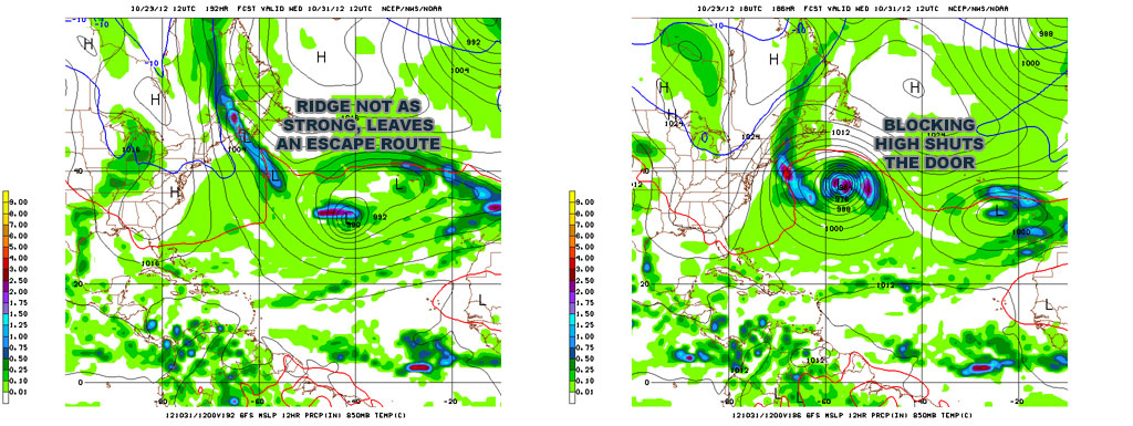
GFS Model
The 12Z run of the GFS stayed the course with a trip into the Atlantic Ocean near Bermuda followed by a backlash storm that develops late next week and has little impact in New England. The 18Z run is the first significant change in the forecast for the GFS since Sunday morning’s run. At 168 hours out (fig. 1), on Tuesday morning, the storm is east-northeast of Bermuda – similar to the position of the 12Z run, but the 12Z run gets to that spot 18 hours earlier. The slower progression of the storm in the 18z run allows a strong ridge to build (fig. 2) in advance of the storm over the North Atlantic Ocean. The result is a storm that puts the brakes on and starts to retrograde back toward the United States. By 240h (10 days from now!) the storm is over Nova Scotia and lashing Eastern New England with wind, rain, and waves. I will be very curious to see if the 00Z run continues this trend because this solution, while not even close to the ECMWF solution, at least has the similarity of an anomalously strong ridge over the N. Atlantic preventing the storm from heading all the way east.
[threecol_one]


Thoughts on the model
The GFS is getting battered and bruised in some weather circles for quickly bailing on the mega-storm solution it had Sunday morning. Today at 18Z, it started to find its way back to a solution that takes into account the super strong blocking pattern that is in place. I think the GFS is a little too far east with the storm after it leaves the Bahamas. I don’t envision Sandy getting east of Bermuda and then pinwheeling all the way around to Nova Scotia. As a result, I think we’ll see a westward trend with the GFS that allows for something closer to, but not the same as, the ECMWF solution that we’ll be talking about in the next post later Tuesday evening.
UPDATE
The 18Z GFS Ensembles are no longer split 50/50 on the east or west track. Now, the vast majority do not let the storm get into the Eastern Atlantic, and many slam New England.


