While the overnight computer models have not changed significantly with their projections for Sandy, there are now two primary scenarios that are taking shape among most of the models. There are still some computer models that take Sandy, evolving into a post-tropical cyclone, and slam it into the East Coast of the United States somewhere between the Mid-Atlantic and Southern New England. Most computer models that don’t have that solution have a scenario where the center of Sandy stays off shore, but, a second storm (Son of Sandy) forms in its wake off the New England coast. The second storm, while not as powerful as Sandy is projected to be, is still a Nor’easter with some heavy rain, gusty wind, and rough seas/surf. Below is a brief breakdown of some of the different computer models.
GFS Model
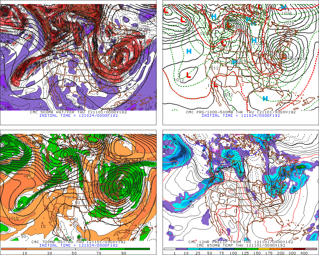
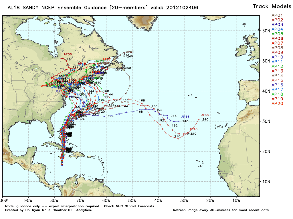
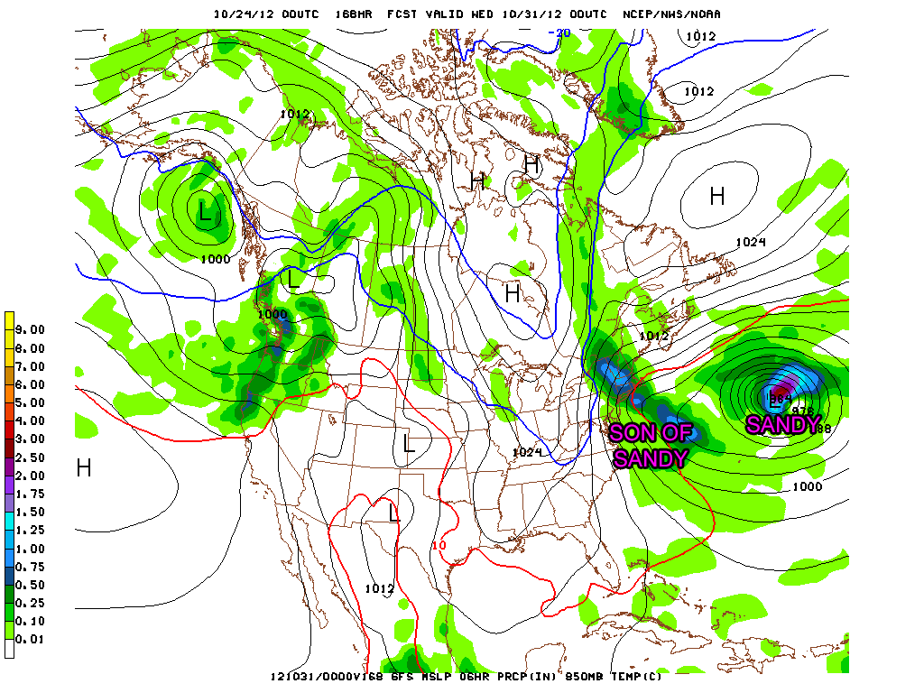
The GFS has been most consistent in keeping the center of Sandy’s circulation well offshore. Some past model runs have allowed Sandy to escape into the Central Atlantic Ocean without there being any nasty weather in the Northeast. That scenario is becoming more unlikely, as recent model runs of the operational GFS model spawn a second storm (fig 1) in Sandy’s wake that leads to some heavy rain and gusty wind in the Mid-Atlantic and/or New England. While not the big storm Sandy is, this second storm is still capable of bringing some nasty weather, but nothing that will be remembered for a long time. The GFS Ensemble members (fig 2) are still split on sending Sandy to the east or bringing it to the Northeast, but the split is now heavily favored toward the storm reaching the Northeast. The GFS computer model runs over the next couple of days will either muddy the waters or clinch the deal for Sandy. The trend with the GFS has clearly been for a more westward track with Sandy over the past 24 hours. The Son of Sandy storm is an indication that the model is showing some interaction with the trough (fig 3) moving through the Great Lakes. It will be interesting to see if the model goes completely over to the ECMWF scenario of the trough capturing Sandy and drawing the main circulation back to the coast rather than spawning a second storm.
ECMWF Model
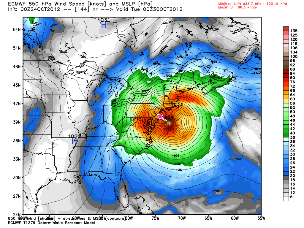
Images of the ECMWF European Model are now being splashed across the front page of newspapers due to its dire forecasts regarding Sandy. Unfortunately, it has not backed off of a historically strong storm slamming into the Northeast. The overnight model run is actually a bit farther south with landfall early Tuesday on the Jersey Shore instead of Long Island. The newest model run has a quicker interaction between Sandy and the approaching trough in the Central United States. As a result, it turns the storm to the west sooner than prior runs, that leads to a landfall farther to the south. Once again the central pressure for the storm is off the charts at 934 mb (fig 4) when the storm is about 100 miles south of Long Island and east of New Jersey. I can’t fathom the pressure of the storm getting that low, but, even if it’s 25 mb higher, you’re still looking at a monster storm. If the storm takes the track into the Mid-Atlantic, that will mean less rain for New England, but the potential for some very strong southeast winds, and a significant storm surge, coastal flooding, and beach erosion. Keep in mind, it’s a full moon on Monday, so tides are running higher than normal. The ECMWF has been scary consistent with intensity and track of this storm for several days. If there are not wholesale changes to its projection over the next couple of days, then the area within 100 miles of landfall will need to prepare for a storm that will rival anything most of us have ever seen.
Canadian Model
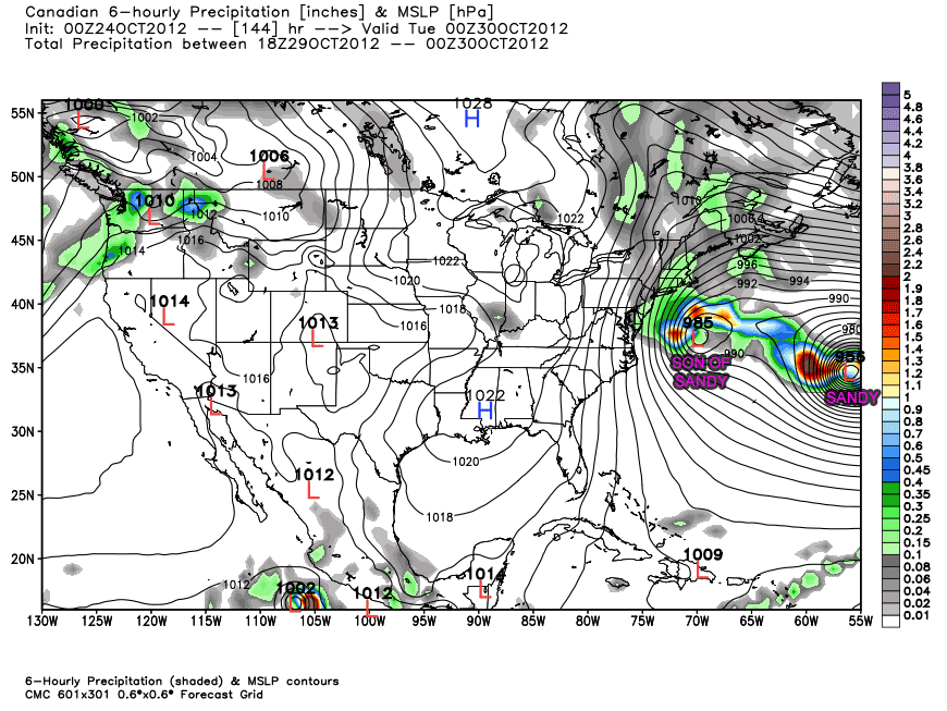
The Canadian model has now shifted into the GFS camp of sending Sandy out to sea but not before it helps to spawn Son of Sandy (fig 5) off the Mid-Atlantic coast as the trough approaches from the west. SOS then proceeds to sit and spin for a few days whipping rain, wind, and surf into New England. It would be a nasty Nor’easter, but probably not a storm of historic proportions. Because the storm is nearly stationary, we would still have some rain around (fig 6) on Halloween. This is another case where Sandy escapes, but the end result is still some rough weather in the Northeast.
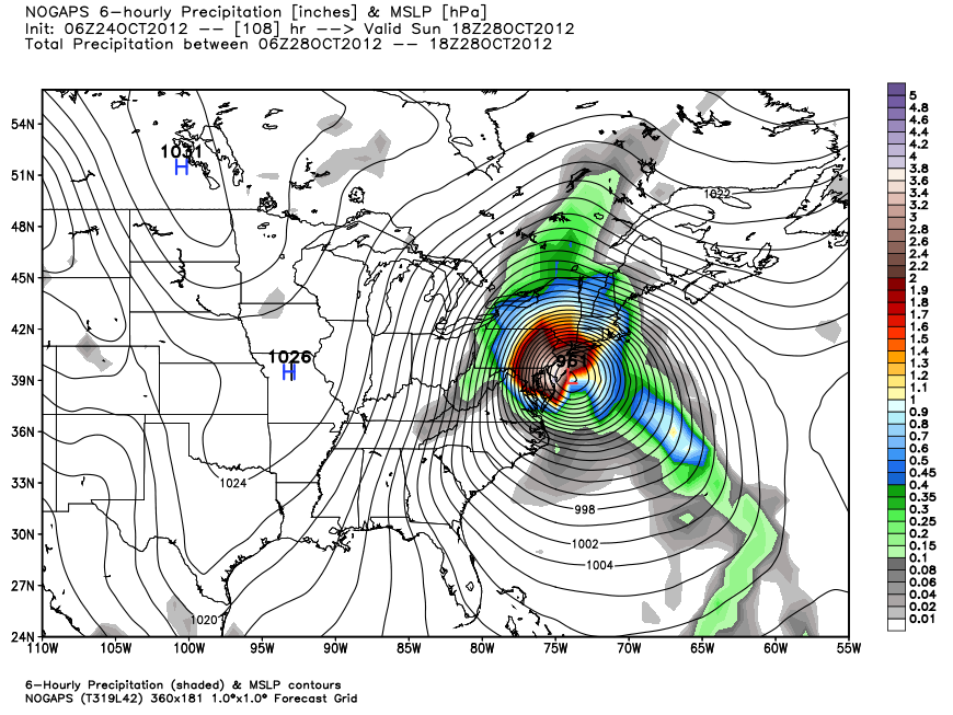
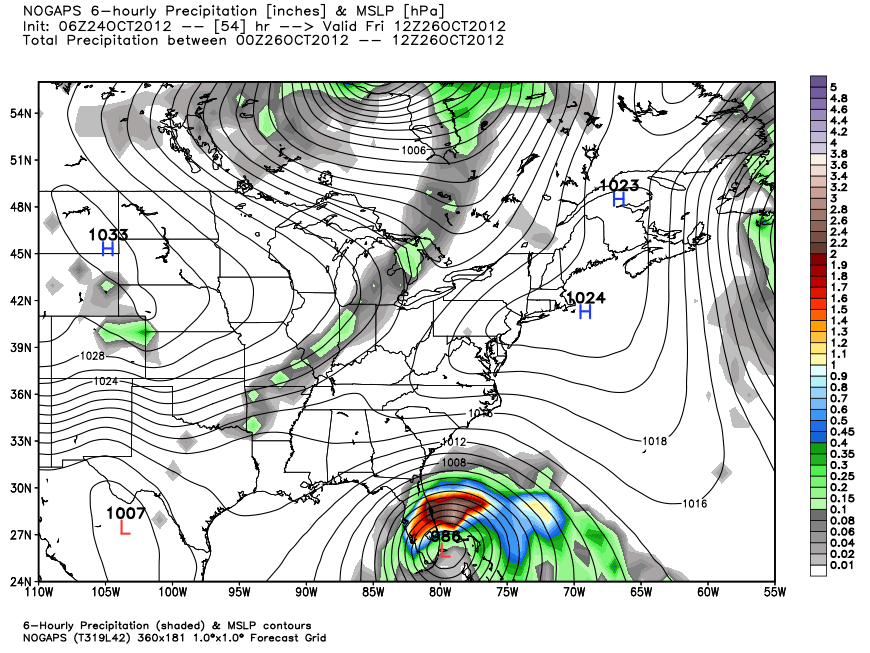
NOGAPS Model
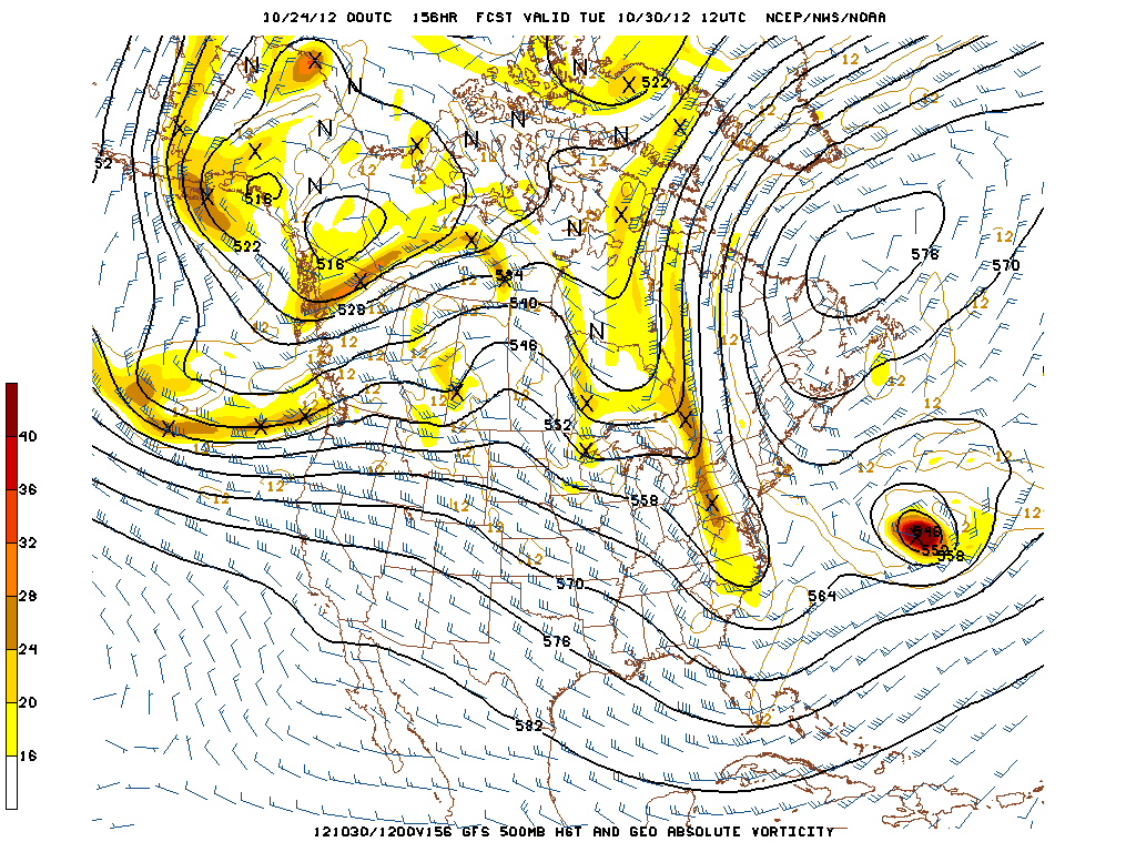
The NOGAPS model runs have consistently brought the center of Sandy to the Mid-Atlantic or New England for the past several days. The overnight run is a little too far west (fig 7) for my liking with the storm scraping the east coast of Florida before moving just east of Cape Hatteras, and then inland (fig 8) on the Jersey Shore. While the overall scenario (track and intensity) are plausible, the timing is suspect, with the storm reaching New Jersey by midday Sunday. This is 1-2 days early than the other models that have a direct Northeast impact. As a result, I’m likely going to remove the NOGAPS from future computer model discussions until I get some indication that its timing may be correct.
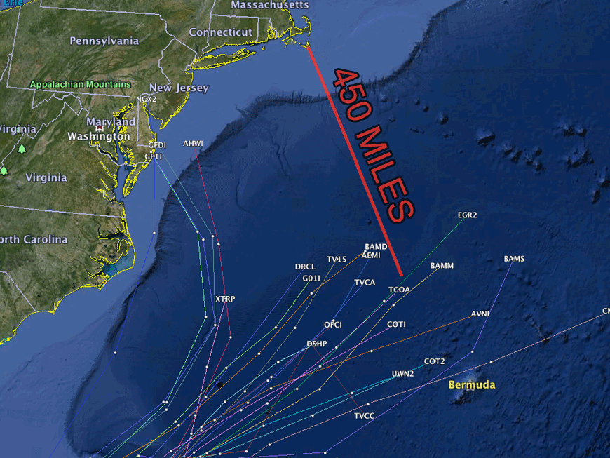
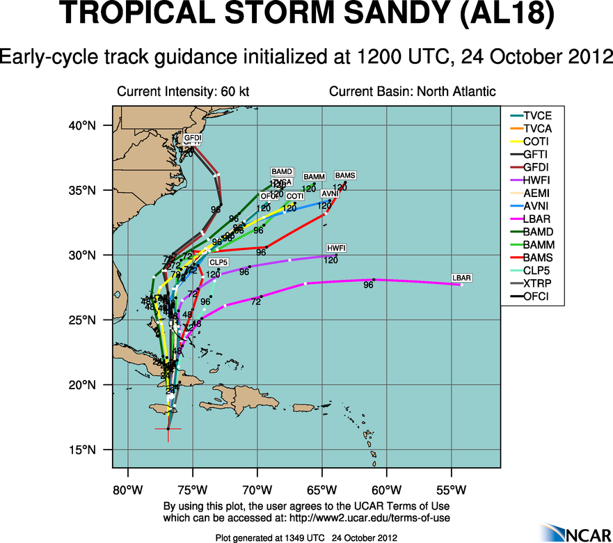
Hurricane Models
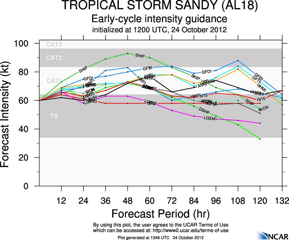
The 12Z Wednesday early hurricane guidance shows Sandy’s potential escape hatch south of Bermuda (fig 9) closing quickly. Nearly all the models track the storm west of Bermuda, within 400-600 miles (fig 10) of Nantucket by early Monday morning. With the synoptic weather pattern that is likely to be in place by then, it is more likely that the storm will turn north and northwest then continue moving northeast. At the very least, the storm would end up in Nova Scotia, in a worst-case scenario for New England, it would turn north then northwest and high between Nantucket and New York City. The intensity guidance (fig 11) is slightly stronger than prior runs with the consensus forecast between 65-90 mph by Sunday PM.
The Bottom Line
This is a supercharged setup for a big storm to have a major impact in the Northeastern United States. It’s like an all-star game of meteorological players on the field. There is a stronger than normal ridge over the North Atlantic, a strong trough cutting through the Midwest, and a strong ridge on the West Coast. There is a large late-season tropical system about to enter the Bahamas. The ocean temperature off the Southeastern US coast is warmer than normal. All of these factors are conspiring to bring a major meteorological event to all or part of the Megalopolis from Boston to Washington, DC. The least likely scenario at this point is the storm having zero impact in the Northeast. It’s still not 100% certain that the storm won’t head out to sea, but the odds have shifted to strongly favor a storm for the Northeast. Questions remain, however, as to the extent of the storm that will likely hit the Northeast. Right now, it’s about 50/50 in the computer model camps between bringing post-tropical Sandy directly to the Mid-Atlantic or New England, or having a secondary Nor’easter form in the wake of Sandy as the main circulation moves east into the Central Atlantic Ocean. In the second scenario, it’s also possible that Sandy’s circulation dumbbells around the new storm and moves northwest into Nova Scotia, but we won’t delve too deeply into that right now. For now, the bottom line is keep a close eye on the forecast, make some contingency plans to take in the lawn furniture, kids toys, awnings, etc. this weekend, seriously consider allowing some time to pull the boat Saturday or Sunday, and picking up a few extra batteries on your weekly trip to the grocery store – just in case.