
There is likely to be a lot of ebb and flow with the computer model projections for Tropical Storm Sandy over the next 4-6 days. The overall trend overnight with Tropical Storm Sandy has been for a higher impact scenario in the Northeast, particularly Southern New England. Similar to Monday night’s update, I will be breaking down the models individually, and then add some bottom-line thoughts at the end of the column.
GFS Model
The 0Z and 06Z runs of the GFS continue to take the center of Sandy out into the Central Atlantic Ocean. Both runs, however, hang a trough to the west of the storm that spawns another circulation east of Cape Cod. At that point, there is a Fujiwhara Effect between the two systems where they dumbbell around one another. The end result is the coast of New England gets lashed with some wind and rain, but it’s likely not as bad as a direct hit from Sandy’s original circulation. The GFS has certainly backed off its bullishness on the storm escaping out to sea with no impact in New England. One of the big difference between the GFS and other models is timing. Because there is no direct impact from Sandy, it takes a while for the other system to evolve, and the main impacts are felt on Halloween and Nov. 1. Right now, this model looks like an outlier – that’s not a good thing for Southern New England.

Source: mag.ncep.noaa.gov via Right on Pinterest
ECMWF Model
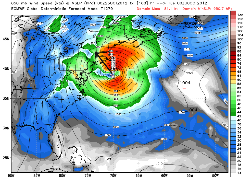
The ECMWF track has not changed a ton since Monday evening, but the intensity has gone from armageddon to just really strong. If the ECMWF verifies, it will be a storm to remember for a long time for a number of reasons. The track of the storm is one that is potentially very destructive for the Southern New England coast. It doesn’t matter if it is a pure hurricane or, much more likely, a storm that is becoming extra-tropical, any storm with a central pressure near 950mb when it crosses Eastern Long Island and heads northwest is sure to throw a storm surge and screaming winds into the coast. The amazing thing about this scenario is that the storm has two faces, the western side of the storm brings heavy snow to the Appalachian Mountains. The timing of the storm has changed with the ECMWF. It is quicker than it was on Monday. The storm arrives on Monday and lasts into Monday night.

GDPS (Canadian Model) and NOGAPS Model
Both of these models have been predicting a storm for the Northeast and Mid-Atlantic for a couple of days. Monday night’s computer model runs were no different. The Canadian is a bit farther east than prior runs, with the storm coming offshore up the coast then turning to the northwest, similar to the ECMWF, and hammering New England. The NOGAPS is similarly destructive. If you’re keeping score at home, that’s three out of the four models we have analyzed bring a major storm to New England. The trend is not good.

Source: fnmoc.navy.mil via Right on Pinterest

Source: weatheroffice.gc.ca via Right on Pinterest
06Z NOGAPS – Strong tropical storm or hurricane crossing Long Island on Sunday. Bad news for the Nor http://t.co/TgZGVcyd
— Right Weather (@RightWeather) October 23, 2012
Hurricane Models and National Hurricane Center
The consensus of the hurricane-specific computer models is still to bring the storm to the east, close to Bermuda, and then out into the Central and Northern Atlantic Ocean. There are, however, some simulations that have a track similar to the aforementioned ECMWF, NOGAPS, and Canadian that all turn it to the northwest and into the Northeastern United States. The trend since Monday is farther to the west. The official forecast from the National Hurricane Center does not extend far enough to get an idea on what they’re thinking will happen in the Northeast. According to their technical discussion, the official track of the storm is somewhere between the far western path of the ECMWF and the far eastern path of the HWRF hurricane model. You can see the NHC track on the Hurricane Tracker page on rightweather.net. The intensity forecast from NHC brings Sandy to an 80 mph hurricane when hitting Jamaica and Cuba, then to a 70 mph subtropical storm Saturday as it moves northeast from the Bahamas heading in the general direction of Bermuda.

The Bottom Line
The computer model trend in the past 12-18 hours has not been good for the Northeast. Thankfully, we’re talking about a storm that is still, at least, five days away. The accuracy of 144-168 hour forecasts is nowhere near 100%, but it’s not 0%, either. At this point, I would continue to pay very close attention to this forecast. The synoptic weather setup of a strong, negatively tilted upper-air trough cutting through the Midwest, combined with a strong ridge off both United States coasts, and an upper low in the North/Central Atlantic is close to ideal for bringing a storm to New England if that storm can get far enough north before turning east toward Bermuda. The critical juncture for this storm is once it gets into the Bahamas. If it does not get caught in the westerlies and start accelerating to the northeast, then the East Coast, particularly New England could be in a whole heap of trouble.
The timing of the storm could be anywhere between Sunday and Thursday. Most models that bring a direct impact from Sandy are timing out in the Monday-Tuesday range. Potential impacts include strong, damaging winds, some heavy rain, and a storm surge capable of doing damage. It’s way too early to talk specifics on wind speeds, rain amounts, and storm surge height.


