Sandy track zeroes in on Mid-Atlantic and Southern New England

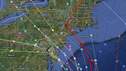
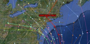
Category 2 Hurricane Sandy was barreling through the Bahamas with winds of 105 mph early Thursday afternoon. The computer model consensus has shifted farther to south, with the the average track being somewhere near New York City. A track into that part of the Northeast puts Southern New England on the drier, but very windy side of the storm. There is also the potential for significant storm surge and coastal flooding during several high tide cycles early next week.

GFS track shifts south, hammers Southern New England
If you’ve been scoring at home, you know that the GFS model had been either taking Sandy out to sea or bringing the storm inland between Maine and Newfoundland during the past several days. This morning’s run has finally come around to a solution that is much closer to what the ECMWF model has been predicting consistently for days. The track of the storm is up the eastern side of the Gulf Stream until it is well east of the Chesapeake Bay, at which point it starts to turn northwest and heads straight for Long Island. On approach to Long Island, the model lowers the central pressure to 941 mb – the equivalent of a borderline category 3/4 hurricane. It’s unlikely the storm will be carrying those winds as it transitions to an extratropical system, but even a category one hurricane approaching from SE to NW can cause major problems in Southern New England.
The storm impacts begin Monday, and the brunt of the storm is Tuesday – per the GFS. Other models are slightly quicker with the storm’s center reaching the coast. At this point, don’t focus on exact timing. Just know that the weather will likely go downhill Sunday night, and bad weather may last into Wednesday because the storm, unlike many Northeast hurricanes, will probably not be a fast mover.
The GFS model brings 40+ mph sustained winds to Block Island and the Rhode Island coast from late Monday night into Wednesday afternoon. The big reason for the prolonged duration of strong winds is the GFS stalls the storm just southeast of New York City before moving it inland across Long Island into Connecticut Wednesday morning. Peak wind gusts near the coast of Southern New England would be 70+ mph if the GFS model is accurate. Believe it or not, with the storm moving into Northern New England by late-Thursday, we would likely see 20-40 mph winds Thursday and Friday, too.
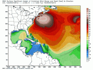
Also, the potential for a significant and damaging storm surge, coastal flooding, and beach erosion event is high based on the GFS track. The predominant wind direction for the start of the storm would be out of the northeast to southeast, and the strongest winds would come from the southeast. The largest storm surge is likely to the northeast of a west-northwestward moving hurricane as it approaches a south or east facing coastline (that’s a mouthful!) – the bottom line is the surge, erosion and flooding damage if the GFS track is correct would be some of the worst in decades. The wave action would be remarkable – a large area near Sandy is projected to have 20-45 foot waves!

Flooding rain is the one thing that Southeastern New England would be spared with a track like the GFS into Long Island or New Jersey. There would be some heavy showers, but the bulk of the rain would be over the Mid-Atlantic States.
Other models also hit Northeast hard
The Canadian and NOGAPS models both bring a substantial hurricane or post-tropical storm to the Northeast. The Canadian model is similar to the GFS, but it does not stall the storm before making landfall near Asbury Park, NJ – appropriate for a storm named Sandy. The Canadian is a bit more intense than the GFS with the central pressure dropping to 939 mb before landfall! Once again, a storm approaching the Jersey Shore from the east-southeast after not having been over land since the Bahamas has the potential to wreak major havoc in the Mid-Atlantic and Southern New England. The Canadian model has the weather deteriorating Sunday night, with brunt of the storm Monday and Monday night. Wind, surge, flood, rain impacts with the Canadian model are similar to the GFS model for Southern New England.
The latest run of the ECMWF (European model), which has been consistent with landfall between Long Island and the DelMarVa Peninsula, is even farther south – bringing the storm into the Chesapeake Bay. While very threatening for the Mid-Atlantic, this would be a best-case scenario for the Southern New England. The model dips the central pressure to an almost unheard of 930 mb before it turns it sharply west and moves it inland. If this pans out, we’ll have some strong winds and coastal flooding, but nothing compared to what we would see if it hit in New Jersey or Long Island. The center of the storm would be 400 miles away, instead of less than 150 miles away.
The bottom line is all the computer models have trended south this morning. All of the computer models also have a very intense storm for the Mid-Atlantic and/or New England. The difference between a storm that hits near the North Carolina/Virginia border and one that hits Long Island is huge for Southern New England. The track to Long Island is a historic storm for Southern New England. The track to the Chesapeake Bay brings wind/waves/rain, but nothing that New Englanders can’t handle.
At this point, I would not bank on any one scenario. Check the link below for details on how to be prepared if Southern New England gets the worst of it.
Preparedness links available here.
http://bit.ly/rightwx-prepare


