Tropical Storm Sandy was nearing hurricane strength Wednesday morning as the center of the storm approached Jamaica. At 5 am, the storm had 70 mph winds, a central pressure of 986 mb, and was 120 mi south of Kingston, Jamaica. The National Hurricane Center forecast continues to take Sandy directly over Jamaica and Eastern Cuba, then just east of Nassau, Bahamas by Friday afternoon. After that, a turn to the northeast is anticipated at the same time that the storm starts to lose some of its tropical characteristics. Even though it may not be a purely tropical system by late this weekend, it is still expected to be a strong storm with near-hurricane force winds.


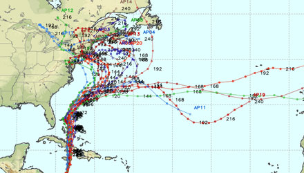
Overnight Computer Models
There has not been a lot of significant change in the forecast from the myriad of computer models overnight. There are still several computer models that bring the center of the storm to the Northeast United States next Monday and/or Tuesday. Many other models, while not bringing the center of Sandy’s circulation to the Northeast, form another storm in the wake of Sandy that also brings some rain to the Northeast, but not the strong, damaging wind and potentially destructive storm surge and waves. The odds of their being some impact from Sandy or a storm spawned by Sandy are increasing for New England and the Mid-Atlantic. The likely timeframe for any inclement weather is between late-Sunday and Tuesday if there is a direct hit from the system, and from Monday-Thursday if the center of the storm moves to the east, but a second, weaker storm forms near the New England coast.
At this point, there is still plenty of time to prepare for either scenario. If your boat has not been pulled for the season, I would definitely make sure arrangements are made to have that done by Saturday. Sandy is likely to churn up the Atlantic, and even if the center of the storm stays away, there should be some high seas and rough surf most of next week. It’s also a good time to consider bringing in the lawn furniture and kids toys. While there is no guarantee for tropical storm force winds, the potential for, at least, a nasty Nor’easter continues to grow.

Main threats
- Strong, damaging wind. This is highly dependent on the track of the storm. If it moves inland to our south or west, then we get a strong easterly-southeasterly wind. If it moves well to our east, the wind will be between northeast and northwest. Wind speed potential ranges from a windy day without damage to stronger than the winds we received from Tropical Storm Irene last year. There is still a wide range of possibilities.
- Heavy rain. Anytime a tropical system is involved, there is the potential for some heavy rain. Right now, it’s too early to say if that will lead to flooding, but for some near the center of either Sandy or a storm that Sandy spawns, there will likely be several inches of rain – that would be enough to lead to some flooding. The potential long duration of the event, may also lead to rising rivers or streams somewhere in the Northeast (it’s too early to say where) by late next week.
- Coastal flooding / storm surge. As mentioned earlier, there is likely to be some very rough surf and high seas regardless of how close the center of Sandy comes to New England. If the center of the storm moves onshore between Long Island and New Jersey as some models are predicting, then Southern New England will experience a some coastal flooding and beach erosion – the magnitude of it will depend on the strength of the storm, but it could be significant. If Sandy stays offshore, and the second storm forms, it is likely that the Eastern Massachusetts coast will get the brunt of the waves and high seas.
The bottom line
Confidence is growing in a storm hitting the Northeast next week. It is still unclear if it will be Sandy or “Son of Sandy”, and it continues to be a situation worth monitoring. While every scenario from a monster storm to a close call remains on the table, the odds have shifted away from a scenario where New England gets zero impact from this system. The jet stream will be configured in a way that strongly favors some stormy weather in the Northeastern United States, so, even if Sandy escapes into the Central Atlantic, I still expect a storm to form east of New England and bring some lousy weather next week.


