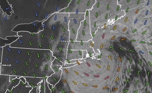
It has been a rough stretch of weather for the past couple of weeks in Southern New England. First, hybrid Hurricane Sandy, now a nasty Nor’easter that would not quit, bringing howling winds for two straight days. The wind will stay active in Eastern Massachusetts Thursday night, but it will finally relax to just breezy conditions in Rhode Island. The storm stalled over Nantucket around midday Thursday, and was on the move to the east by late in the day. Nantucket had a 24 hour stretch of wicked winds, with gusts to nearly 60 hours for nine straight hours. The final snow totals for Southern New England ranged from nada for Southern RI and most of SE MA, to over a foot of wet, heavy snow in SW CT. Officially, there was 1.3″ of snow at TF Green Airport – not that much, but enough to set a record for the date.

Jet stream pattern shifts
The pattern that conspired to bring Hurricane Sandy to the Mid-Atlantic and New England, followed by the Nor’easter less than ten days later, is shifting to one which keeps the storm track to our west, allowing for some warmer weather to return to Southern New England. Another one of those Weather Channel named winter storms will bring a blizzard to Montana and the Dakotas over the next few days, but the Northeast will be spared the wintry side of that storm. High pressure will arrive on Friday, and with a lot of sunshine, the temperature should approach 50 degrees – still about 5-7 degrees cooler than normal for early-November.
It will be partly to mostly cloudy on Saturday, and a few degrees warmer, with highs in the low 50s. A warm front will lift to our north Saturday night, and that opens the door to a southwesterly wind and some much milder weather early next week. It may not reach Indian Summer levels, but 60 degrees is a reasonable goal for Sunday, and Monday may reach 65. The southwest breeze will cool the coast, so you can expect it to be about 5-10 degrees cooler close to the ocean both days. Skies will be partly sunny Sunday, and mostly sunny Monday. It will be relatively mild at night, too. Lows will be in the upper 40s to low 50s Monday and Tuesday morning, rather than the mid to upper 30s that are typical this time of the year.
A cold front associated with that Upper Midwest blizzard will bring a round of showers on Tuesday. It will still be relatively mild with highs in the 50s and 60s. Cooler, dry weather is likely from Wednesday through late next week.


